Reports
MoreCare Project
Project “Measures for conservation and restoration of natural heritage in Burgas and Enez”


“Measures for conservation and restoration of natural heritage in Bourgas and Enez, Programme”, More Care, IPA CBC Bulgaria- Turkey 2014 -2020
“ Development of a joint model and an assessment methodology for ecosystem services in Vaya (Burgas) and Gala (Enez) lakes ”, Reference number: CB005.1.12.115/S-4
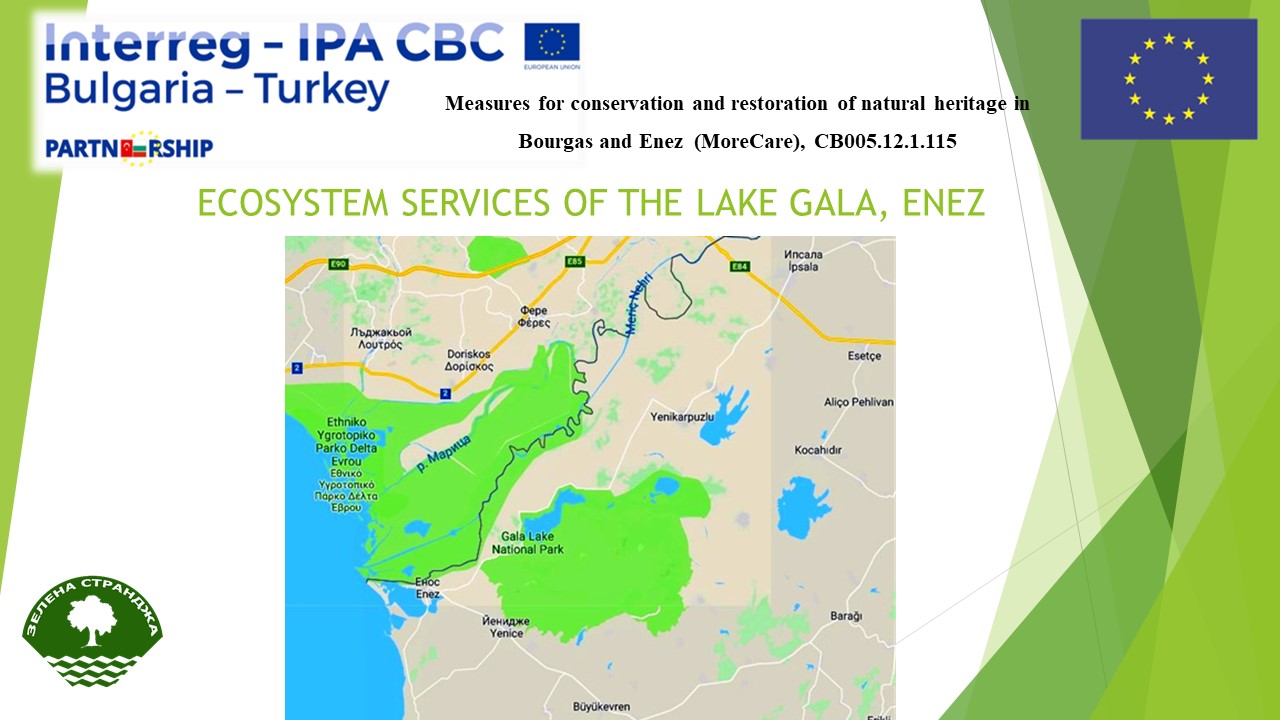
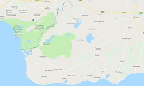
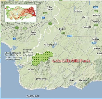
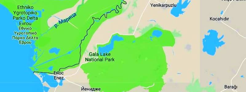
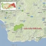
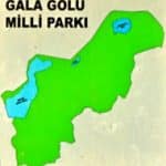
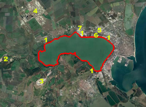
Gala Lake – Map
MAPPING of ecosystem resources and services in region of Gala Lake
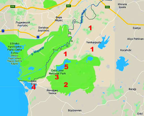
Leggend:
1 – Rice fields;
2 – Wind power generators park;
3 – Pastures;
4 – Historical sites;
5 – Visitors tower;

You can download the file from the link above.
Measures for conservation and restoration of natural heritage in Bourgas and Enez (MoreCare), CB005.12.1.115
“Development of a joint model and an assessment methodology for ecosystem services in Vaya (Burgas) and Gala (Enez) lakes”, CB005.1.12.115/S-4
ECOSYSTEM RESOURSES LAKE GALA
Experts:
Maria Broshtilova
Vladimir Dimitrov
GREEN STRANDJA ASSOCIATION
Burgas, October 2018
ECOSYSTEM RESOURSES AND SERVICES IN GALA LAKE, ENEZ
Coordinates – 40.772403, 26.190290
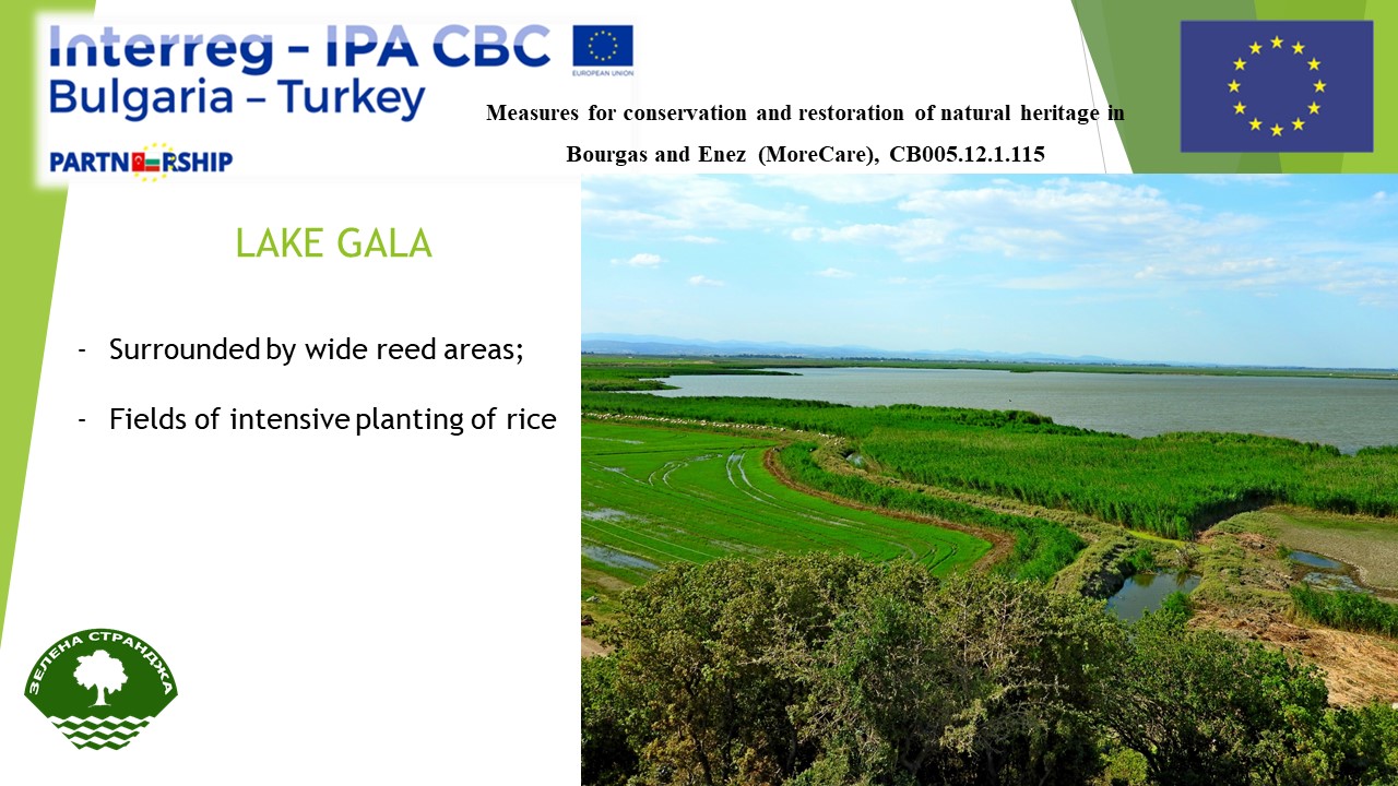
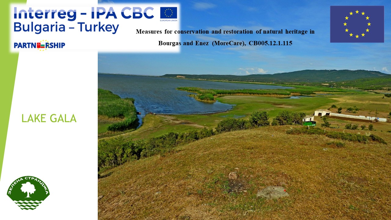
Lake Gala is an alluvial freshwater dam lake located between Ipsala and Enez counties, 10 km away from Enez town and 23 km away from Ipsala town, in Edirne province in Turkey, near to the delta of Maritsa River. It consists of two parts named Lake Big Gala and Lake Small Gala. It has 5.6 km2 surface area and it is 2 m above the sea level. The depth varies between 0.4-2.2 m. It is fed by drainage canal (Basamaklar Stream), Kızkapan Stream, other small streams and rain. The lake is surrounded by wide reed areas (Phragmites australis and Thypasp.). The agricultural land in the neighborhood of the lake between Enez and Ipsala is used for industrial planting of rice.
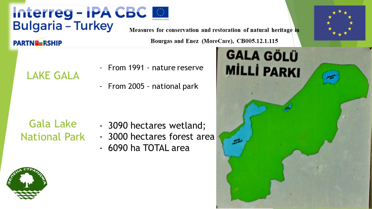
From 1991 the Gala Lake is part of nature reserve and taken under protection. In 1997 Gala lake have been declared as a wetland of international importance under the Ramsar Convention without specific area. In 2005 the lake and its surroundings have been declared as a national park and covers an area consisting of 3090 hectares of wetland (Great Gala Lake, Little Gala Lake, Cotton Lake) and 3000 hectares of forest area (Hisli Mountain).
The protected area is administered by the Directorate of Nature Protection and National Parks (Turkish: Doğa Koruma ve Milli Parklar Genel Müdürlüğü) of the Ministry of Environment and Forests.
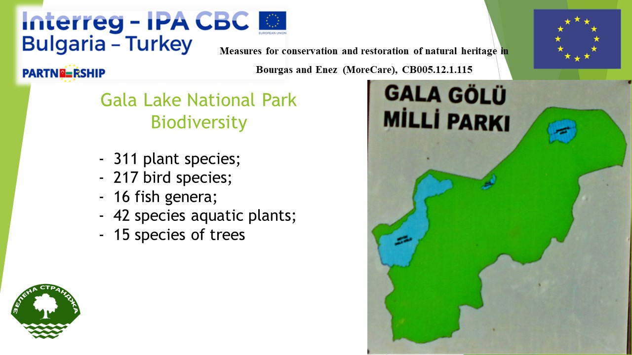
The biodiversity in the Maritza delta, despite some losses, is considered very rich. There are 55 species of plant plankton, 31 species of animal plankton (zooplankton), 42 species of aquatic plants in Lake Gala. In the forests around 15 species of trees grow.
In Gala Lake National Park 311 plant species have been identified and 5 of them are endemic. In addition, 59 taxa are suitable for medical and ornamental usage. In the lake there are many water lilies. Unique grass, shrub and tree species are found along the shores. 29 herbs are extracted here.
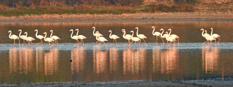
About 46 of 217 bird species observed in the area are resident, 27 winter migratory and 90 summer migratory birds. The Lake Gala is important point of the north-south bird migration route Via Pontica. Best time to observe most of the bird species all together is between April and May in the spring, and September and October in the fall. The lake is home to about 45,000 birds and is located on one of the world’s largest migratory bird routes.
The two Gala lakes are home to 16 fish genera, including European eel (Anguilla anguilla, L.), pike perch (Stizostedion lucioperca L.), common carp (Cyprinus carpio L.) and northern pike (Esox lucius), which are of high economic value.
The area around Lake Gala is subjected to a high anthropogenic load – intensive land use and livestock farming, aquaculture, hunting, wind power generation. Phosphate, Sulphate, Nitrite and Nitrate used in agriculture are expected to be high in the wetlands, such as Lake Gala, that are surrounded by intensive agricultural areas. However, entrance of sulphate and phosphate ions into the lake is partially limited by the dense reed fields between agricultural lands and the lake and also small channels separating it from agricultural areas. This artificial fertilization of wild water plants causes the lake surface to dwindle allowing the reed areas to develop more rapidly. If some physical-chemical parameters like pH, EC and Ca values measured in Lake Gala were compared with similar lakes in Thrace region, it is seen that these values are similar to the lagoon lakes while they are higher than the lakes located entirely within forest.
Lake Gala is mainly fed by the waters of the Maritsa River. The water level in the lake is regulated by a system of channels and locks. This avoids flooding of the farmland around or the water is used for irrigation.
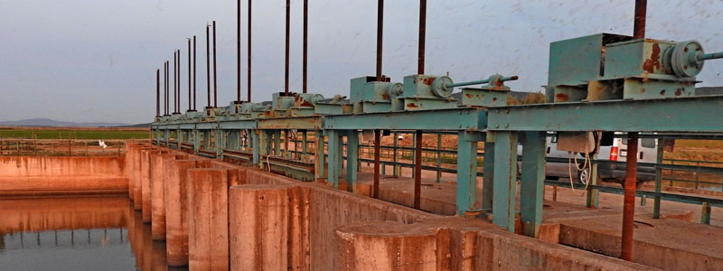
There is a loose dike in the middle of the lake, which is interrupted in certain places to run the water. The plan for management of the National Park provided this dike to be removed.
Lake Gala is known as the second largest bird’s lake in Turkey, and due to its proximity to a metropolis like Istanbul, it is frequently visited. In addition to bird watching and photography, the lake’s activities include picnic, hiking and cycling. Visitors should be very careful not to disturb the natural habitats in the lake.
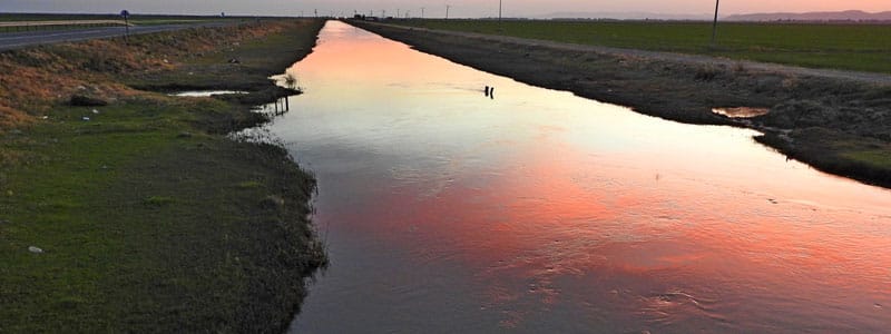
The region of the protected area was fished until 2013, and was banned. A plan is for its gradual recovery. There is fishing in the Maritsa River, in the two dams built around the Maritsa River and in the 30 km long rice paddies built next to Lake Gala. The dams were built in 1991-92 for irrigation of rice fields. The water is pumped through channels specially built by the Water and Waste Directorate of the Ministry of Waters and Forests. Channels protect the pollution of seawater from pesticides and mineral fertilizers used in rice cultivation. Rice plantations provide the main livelihood of the local population.
On the territory of the National Park hunting is prohibited. It is hunted on the territory of the rice fields / winter hunting of ducks /. Hunting is not regulated, no taxes are paid.
Given the great biodiversity in the National Park, the significance of the area as a guardian of genetic resources can be highly appreciated.
Massively along the shores of the lake, cows and sheep are grazing and camping.
Approximately ½ of the water surface is covered by the reed and bulrush. There is a plan to reduce the area covered by plants. It was found that the otter eat roots of reeds and bulrush.
Because of the great opportunities for observation and study of birds today, the park is a favorite place for ornithologists. Students and scientists from Istanbul and Edirne regularly visit the National Park to study biodiversity.
The Gala Lake National Park Directorate plans to build a visitors centre and a 14-kilometer hiking trail with toilets, towers for birdwatching and other interpretive materials for displaying and studying biodiversity.
Possibilities for organizing of water sports and cycling are discussed. There are discussions also on possibilities for combining the natural and archaeological monuments and the sea tourism.
You can download the file from the link above.
Final Report
Atatürk Soil, Water, and Agricultural Meteorology Research Institute
Kırklareli, 18.12.2018
Summary of studies performed under the project:
- Lake Gala water quality studies
- Three sampling points were selected at Lake Gala, and samples were taken for a period of 12 months.
- Physical, chemical, and bacteriological analyses were performed on the water samples taken.
- Results obtained as a result of analyses were evaluated according to parameters as defined under Quality Criteria based on Classification of Intra-continental Surface Water Resources as stipulated under the Regulation on Management of Surface Water Quality.
- Trainings
- We attended a three-day training held in Burgas, Bulgaria on October 9-11, 2017. In the meeting, we made presentations on Lake Gala’s water quality and bird habitat. An on-site visit was made to inspect Lake Vaya.
- A meeting was held by specialists of project parties in order to determine methodologies for water measurements to be performed. A technical visit was made to the water analysis laboratory in Burgas.
- We participated in the meeting held between on October 17-19, 2018 in Enez, Turkey. In the meeting, presentations were made on Lake Gala’s water quality, soil characteristics of agricultural lands surrounding Lake Gala, socioeconomic structure of Province of Edirne, and bird population of Laka Gala. Water samples were taken from Lake Gala, and subjected to analysis according to parameters which could be measured at site. We also watched birds in the immediate vicinity of the Lake.
- Preparation of report
The final report is prepared according to results obtained.
Introduction
Meriç River rising from Rila Mountain (2925 m) in Bulgaria includes the three major tributaries such as Tunca, Arda and Ergene and begins to flow in a wide bed beginning from the North of İpsala. This wide bed, beginning from Meriç-Ergene junction point, is the starting point of Below Meriç Flood Plain. The flood plain scatters beginning from this point and it is turned by Hisarlıdağ volcanic mass in the South and lies rectangular. Gala, Pamuklu and Sığırcı lakes are in Meriç Delta Wetland and they are the outputs of the environment prepared by the alluvions stored by Meriç River. Meriç Delta Wetland and buffer zone in Enez and İpsala districts include total of 27.490 ha area.
Excess waters of Gala Lake are transferred to Enez lagoons via vents and channels constructed by General Directorate of State Hydraulic Works. Therefore, Big Gala Lake, Gala Pond, Pamuklu Lake, Sığırcı Lake (Yeni Karpuzlu Pond), Enez lagoons and Meriç River move as a whole wetland.
When the altitude of Meriç Delta is examined, it is seen that the areas under 35 m include the widest areas. Hisarlı Mountain constitutes the highest zone of Meriç Delta. This mass is formed of volcanic rocks and it is elliptical. Hisarlı Mountain is in the southwest of Gala Lake with some hills over 430 m locally.
Lake Gala is located in a region in Edirne province borders where the river Maritsa meets the Aegean Sea. The lake is 2 meters above sea level and is 10 km far to Enez and Aegean Sea. It is an alluvial set lake lying at 40°46’06.79” N and 26°11’07.63” E and is connected to Maritza River and Saros bay with lake. The depth of the lake varies according to meteorological conditions and to the amount of water used for rice field irrigation. The deepest part of the lake is 2.2 meters during rainy season with increased flood, 1.5 meters during normal conditions and can decrease to 30-40 cm. in dry seasons. During summer, the lake is separated into two sections, Big and Small Gala Lakes, due to drying.
The bank of the lake is accompanied by macrovegetation consisting of Phragmites australis and Typha sp. The lake is surrounded with a lot of agricultural areas where rice plantation is carried out mostly
Gala Lake National Park covers an area of 6.090 ha, of which 3.090 is wetland and 3.000 ha is forest area. In addition, Gala Lake is a part of Maritza Delta listed in class a wetlands and lies along northwest-south axis constituting one of the two main bird migration routes in western Palaearctic region. A total of 163 avian species exist in national park borders of which 46 are native, 27 are winter migrants and 90 are summer migrants. The fish fauna of the region is represented with 16 species among them eel, lucioperca and pike are the prominent taxa of major economic importance.
Gala Lake has a habitat diversity due to the closeness to the sea, forest ecosystem near abroad, meadow areas and highlands. Besides its fresh water and watery environment. As National Park is on North-South bird migration road route passing over Turkey, it is quite appropriate for the activities such as bird observation, habitat observation and nature photography.
Gala and Pamuklu Lakes was given Nature Reserve Area status in 1991 and in 1992, the area around Gala Lake was announced as Natural Protected Area. The region where Gala and Pamuklu Lakes are located was announced as the 36th National Park of Turkey in 2005.
Findings and Discussions
- Results of water quality studies performed on Lake Gala
Under the project, samples were taken from three different sampling points in order to determine the water quality of Lake Gala. Samples were taken on a monthly basis for a period of 12 months in total.
Water samples taken were subject to following physical, chemical, and biological analyses:
- Total dissolved solids (TDS)
- Oxidation-reduction potential (ORP)
- Dissolved oxygen (DO)
- Turbidity (NTU)
- Chlorophyll
- BGA-PC (green algae)
- Biological Oxygen Demand (BOD)
- Chemical Oxygen Demand (COD)
- Ammonium nitrogen(NH4-N)
- Nitrate nitrogen (NO3-N)
- Nitrite nitrogen (NO2-N)
- Phosphor (P)
- pH
- Electrical Conductivity (EC)
- Suspended solids (SS)
- Oil and grease
- Faecal coliform
- Trace elements and inorganic parameters (Mn, Fe, Zn, Cu, Cr, Co, Pb, Ni, Cd)
- Anions and cations (CO3-2, HCO3–, Cl–, Na+, K+, Ca+2, Mg+2)
Sampling points were specifically selected as representative points for Lake’s water quality. Such sampling points are as shown in Figure 1.
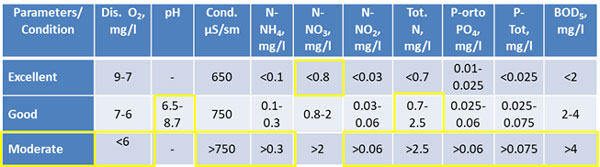
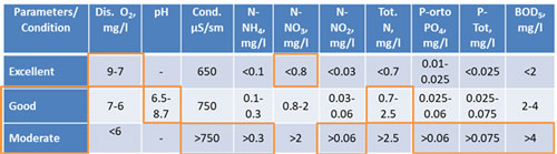
Results of analyses were evaluated according to parameters as defined under Quality Criteria based on Classification of Intra-continental Surface Water Resources as stipulated under the Regulation on Management of Surface Water Quality (Table 1).
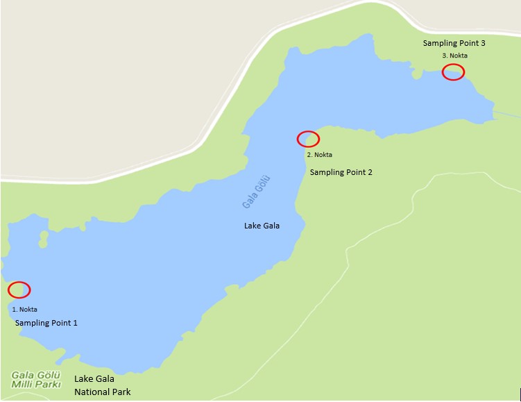
Figure1. Lake Gala Sampling Point
Table 1. Quality Criteria based on Classification of Intra-continent Surface Water Resources (QCCISWR)
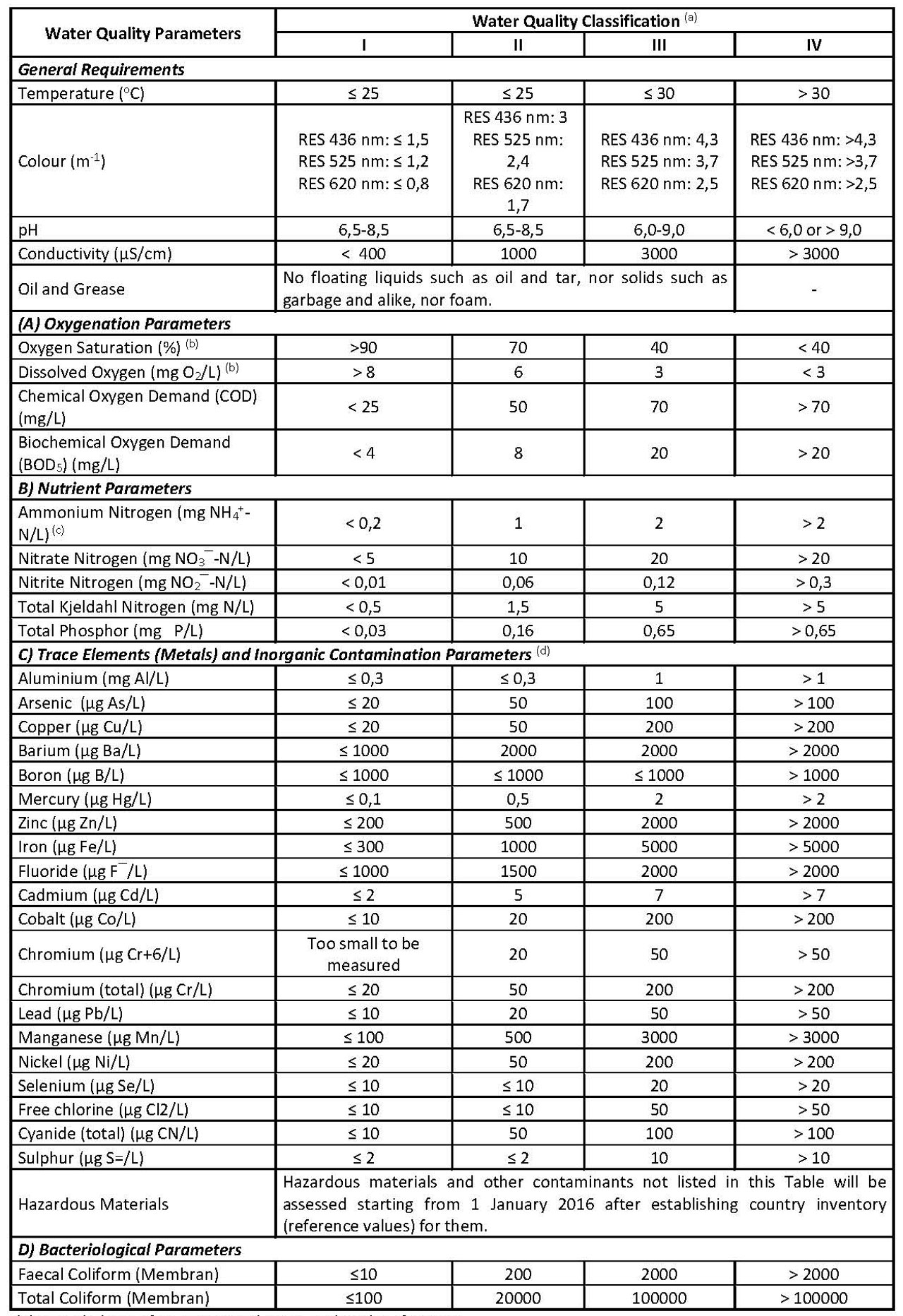
(a) Intended use of waters according to quality classification:
Class I – High quality water (All parameters meeting Class I water quality waters show “Very Good” water quality):
1) Surface waters with a high potential of being used as drinking water,
2) Water which can be used for recreational purposes, including swimming which require contact with body,
3) Water quality suitable for being used for trout farming,
4) Water quality suitable for being used for animal breeding and farm needs.
Class II – Slightly contaminated water (Values between Class I and Class II water qualities show “Good” water quality):
1) Surface waters with a potential for being used as drinking water,
2) Water which can be used for recreational purposes
3) Water which can be used for farming of fishes except for trout,
4) Irrigation water provided that irrigation water criteria as defined under the applicable legislation are met,
Class III – Contaminated water (Values between Class II and Class III water qualities show “Average” water quality):
Water quality suitable for being used for aquaculture or industrial water after suitable treatment, except for facilities which require use of qualified water such as food, textile facilities,
Class VI – Very contaminated water (Values between Class III and Class IV water qualities show “Poor” water quality):
Surface waters which have inferior quality compared to Class III waters, and which can meet parameters of an upper class only after being improved as required.
(b) It is enough to meet either concentration parameter or saturation percentage parameter.
(c) Free ammonia nitrogen concentration should not be greater than 0,02 mg NH3–N/L depending on the pH value.
(d) Criteria relating to that group indicate total concentration of chemical species which constitute parameters.
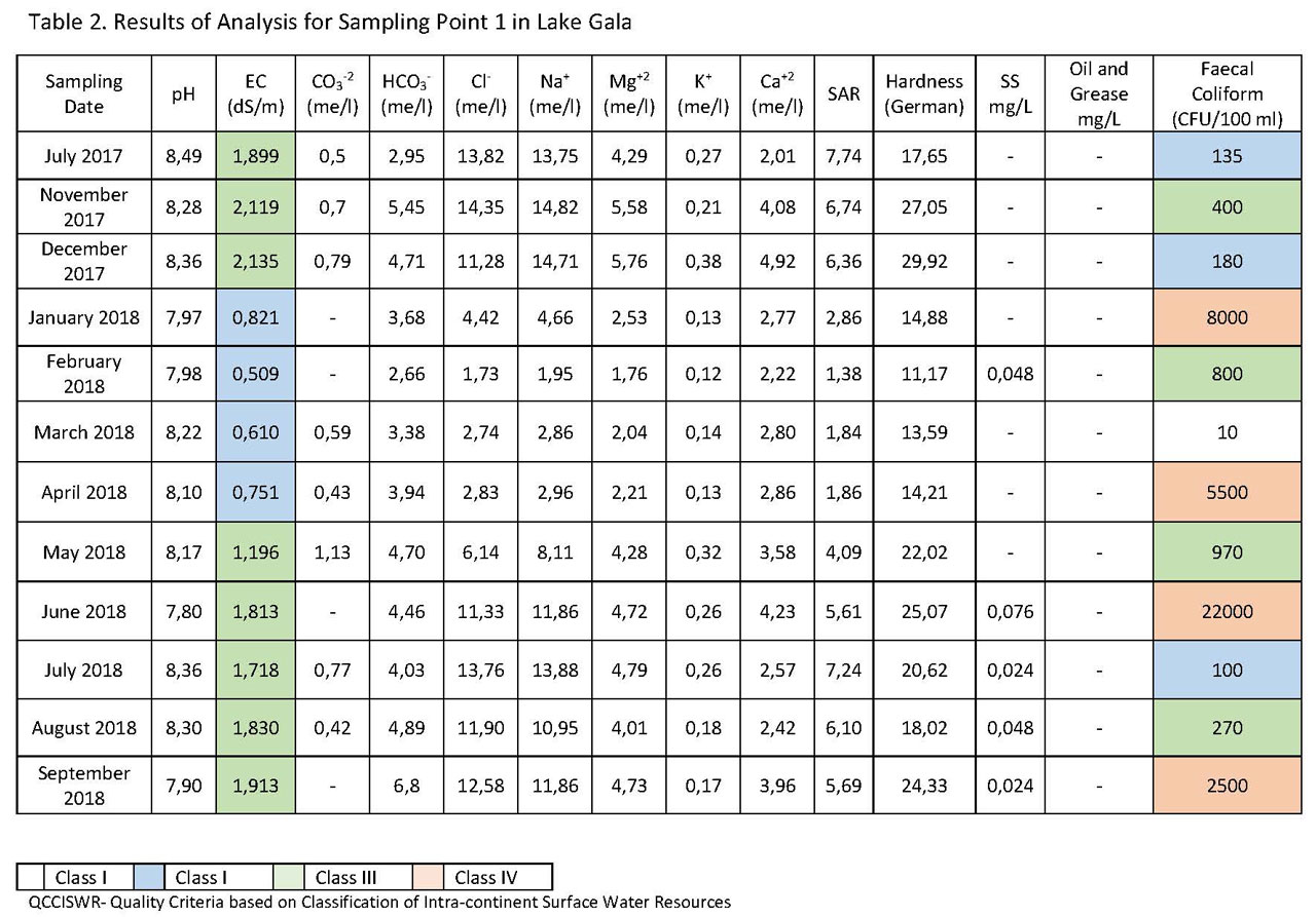
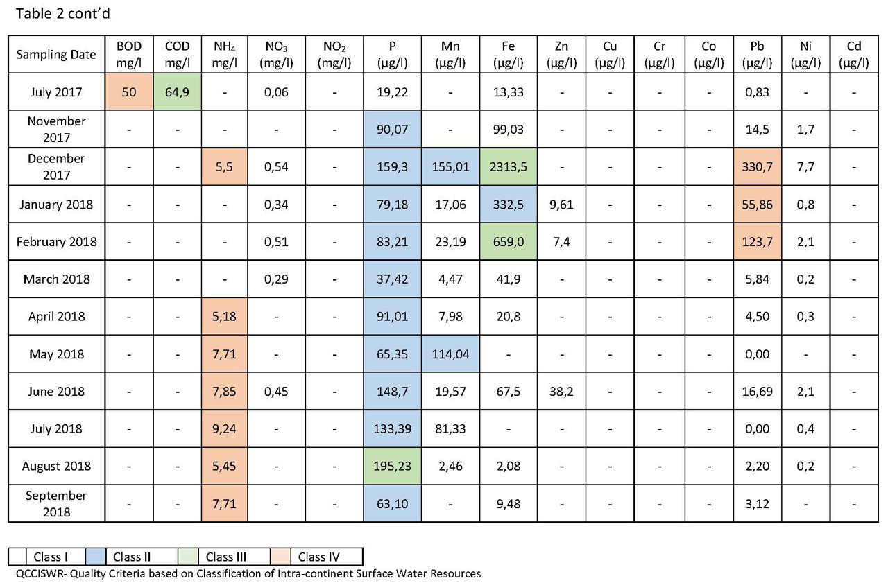
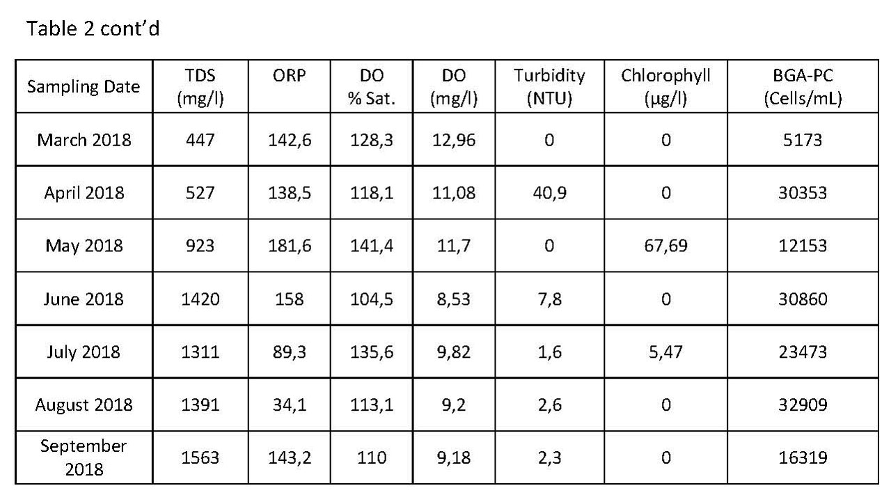
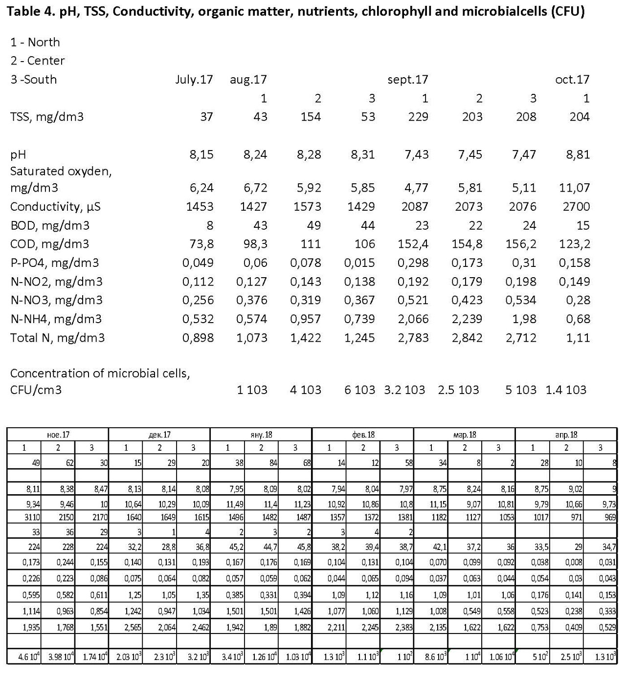
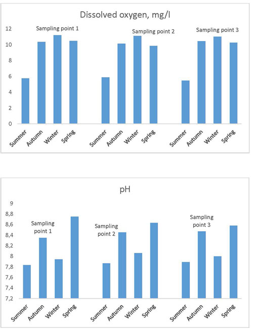
Analysis results of water samples taken from sampling point 1 are as shown in Table 2. According to analysis results listed in the table, in terms of water quality in the sampling point, there is no concern with respect to pH value, and water’s EC values vary between 0,509 and 2,13 dS/m. EC values are in January, February, March, and April 2018 are lower compared to other months, and meet criteria for good water quality. On sampling dates other than the foregoing months, water samples taken from sampling point 1 are classified as Average (Class III) in terms of salinity (1,19 and 2,13 dS/m). When evaluated as per seasons, Lake’s salinity decreases during winter months, and increases during summer months. Such decrease in winter months can be attributed to increasing water quantity in the Lake resulting from increased precipitation during winter months while such increase in summer months can be attributed to decreasing water quantity in the Lake as a result of evaporation during summer months.
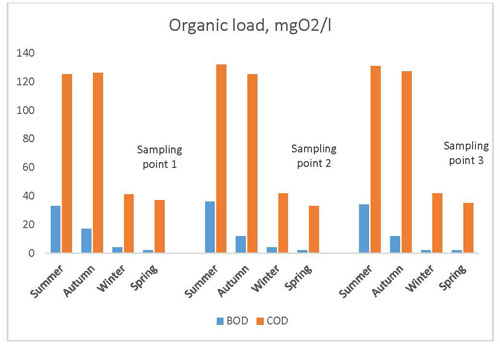
Oxidation parameters, i.e. BOD and COD, were only measured in July 2017, and Lake’s water was classified as very contaminated in terms of BOD, and slightly contaminated in terms of COD.
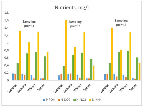
In terms of nutrients parameter, NH4+-N was measured to be between 5,18 and 9,24 mg/l, and accordingly Lake’s water is classified as very contaminated in terms of that parameter. There is no concern with respect to NO3–-N, and no NO2–-N has been detected. Phosphor values vary between 19,22 and 195,23 µg/l which indicates a good water quality. High NH4+-N values may result from intensive use of urea and ammonium in the paddy fields around the Lake used to grow rice, which flows into the Lake water through underground and surface waters after being discharged from the paddy fields.
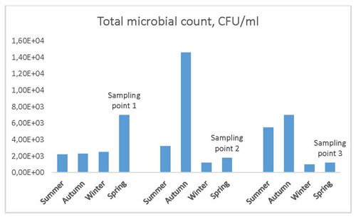
In evaluation of the Lake water in terms of bacteriological parameters (faecal coliform), the Lake water is classified in different contamination levels (II-III-IV) in different months independent of the seasonal conditions.
In terms of trace elements (metals) and Inorganic Contamination Parameters, no matter of concern was observed with the Lake water for Mn, Zn, Cu, Cr Co, Ni, and Cd while Fe was determined to be high in December 2017 and February 2018. Pb values were determined to be high in December 2017, January 2018, and February 2018 while classified as very good quality water for other months.
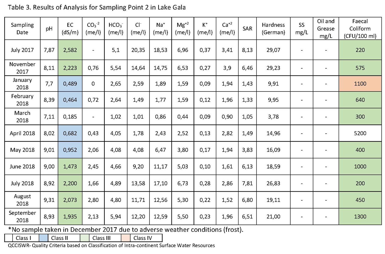
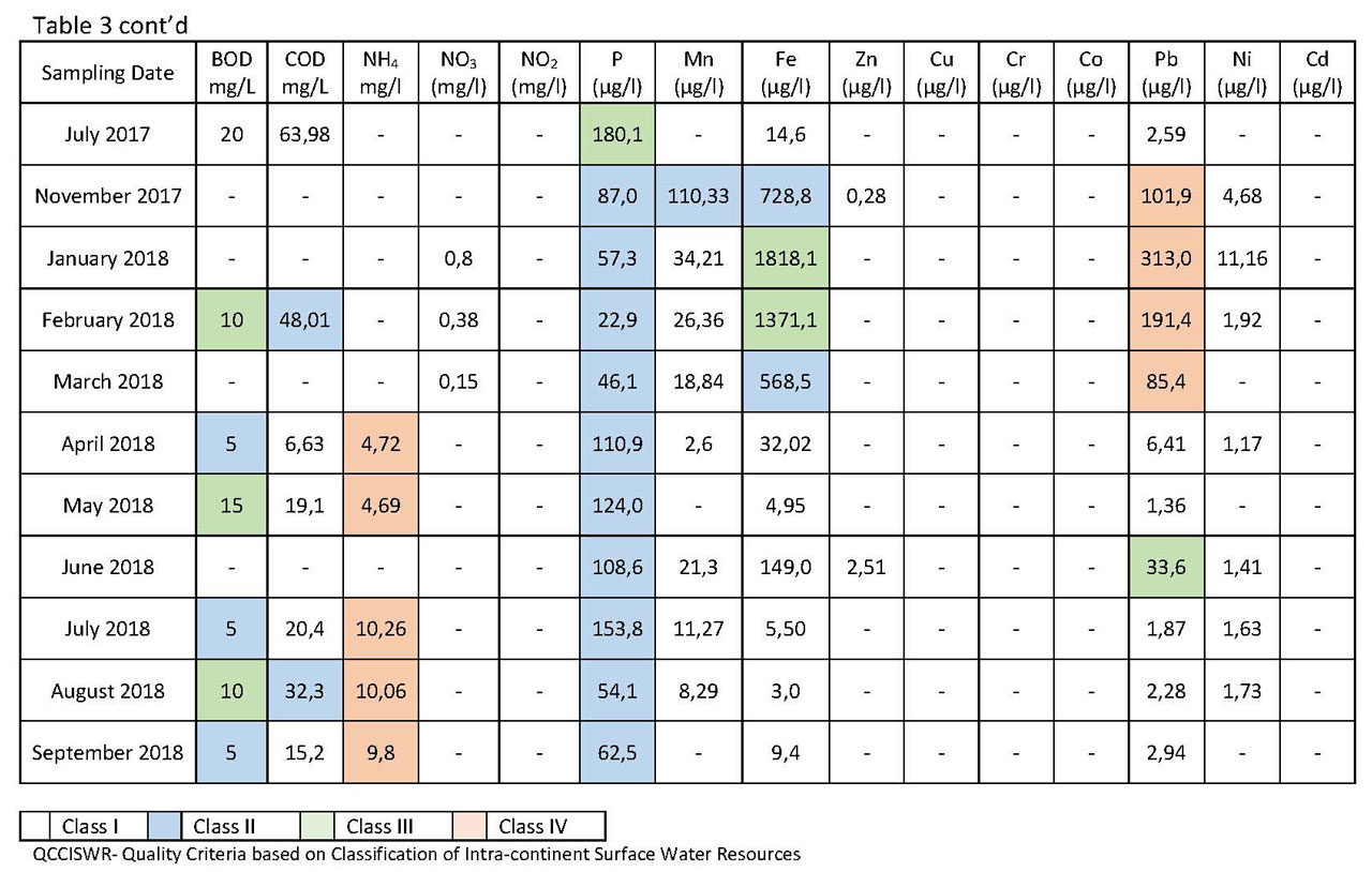
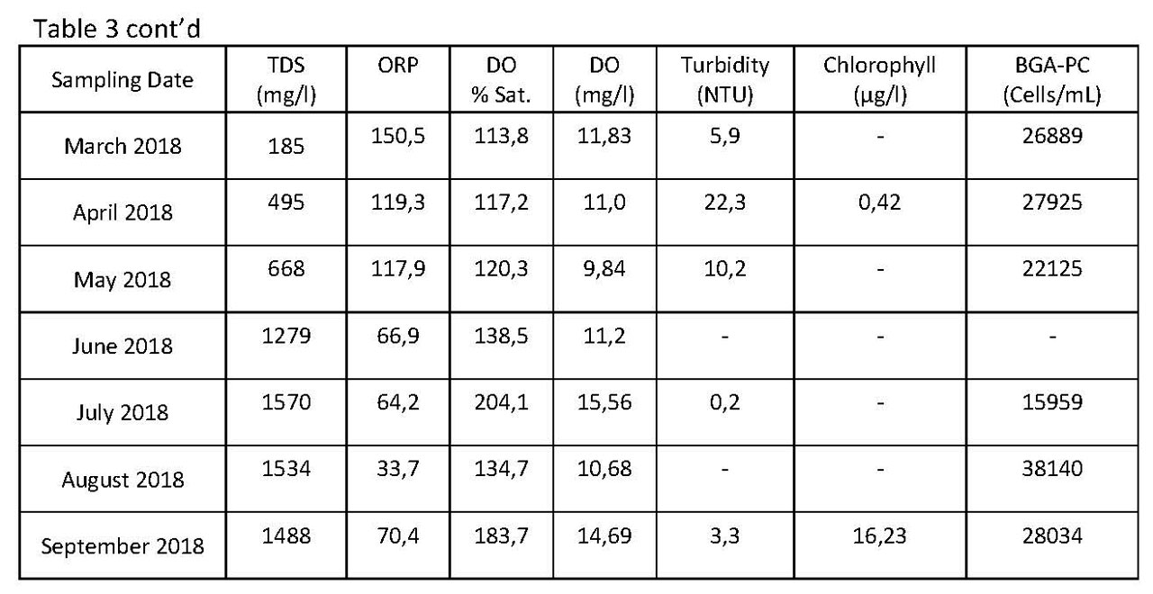
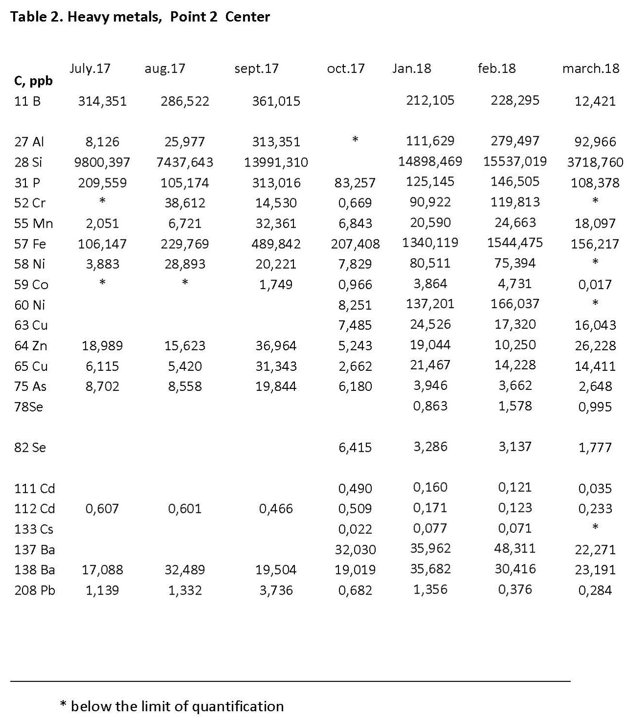
Samples taken from second sampling point of Lake Gala (Table 3):
Though salinity level is not very high, the water quality is classified as very good quality (I) for one month, good quality for four months (0,464 and 0,952 dS m-1), and average quality for six months (1,473 and 2,582 dS m-1).
Lake water is generally classified under Class III in terms of bacteriological contamination.
Water sample taken from the second sampling point was determined to have good and average quality in terms of BOD values while determined to have good quality in terms of COD values.
Of nutrients, only ammonium values increased in some months, and the water quality was classified as poor-very contaminated water.
Phosphorus values were classified as Second II, i.e. very good quality, except for July 2018.
Of trace elements (Metals) and Inorganic Contamination Parameters, only Fe (January 2018 and March 2018) and Pb (November 2017, January-February-March 2018) values were determined to be at level of concern only in some months.
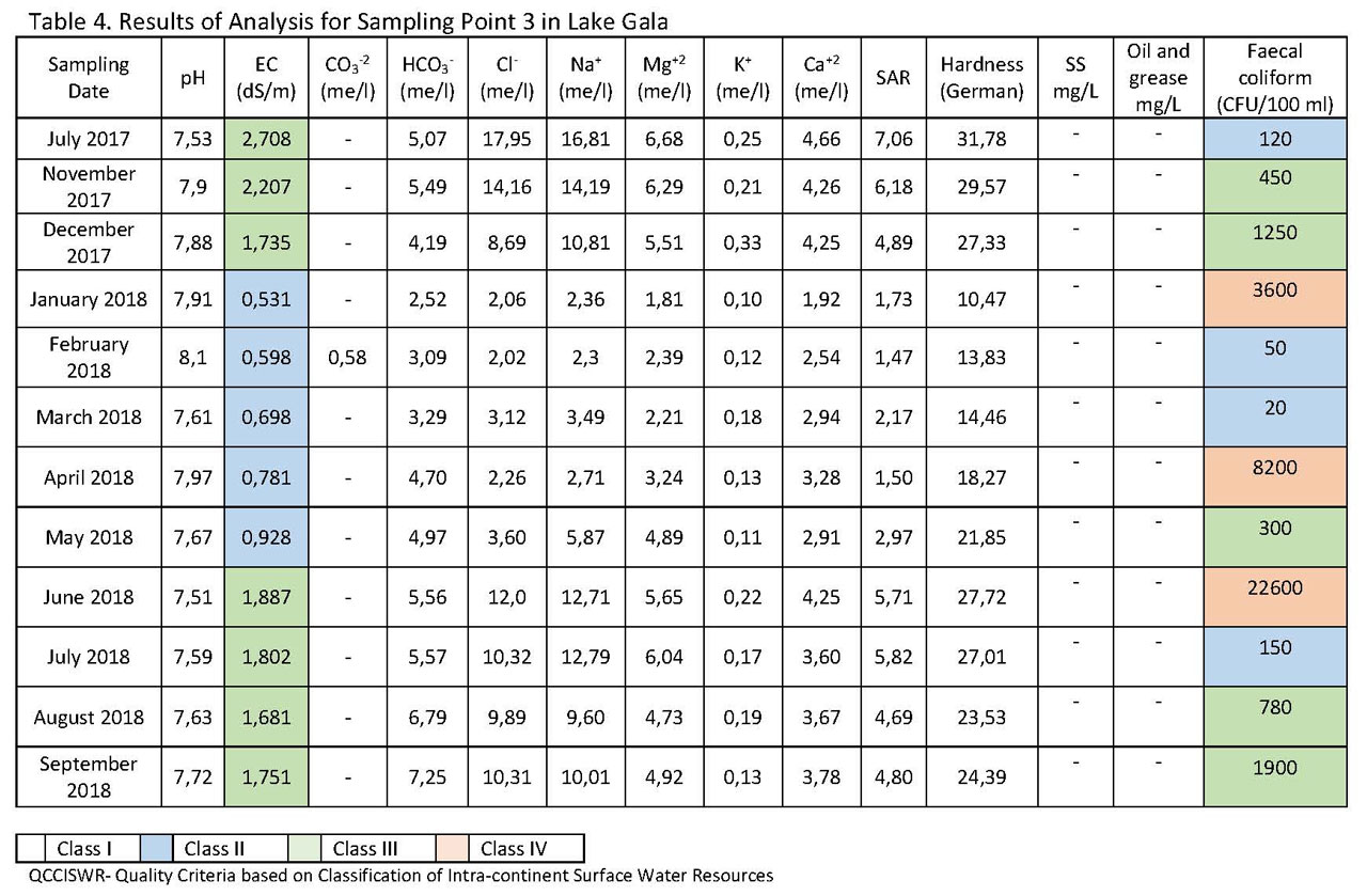
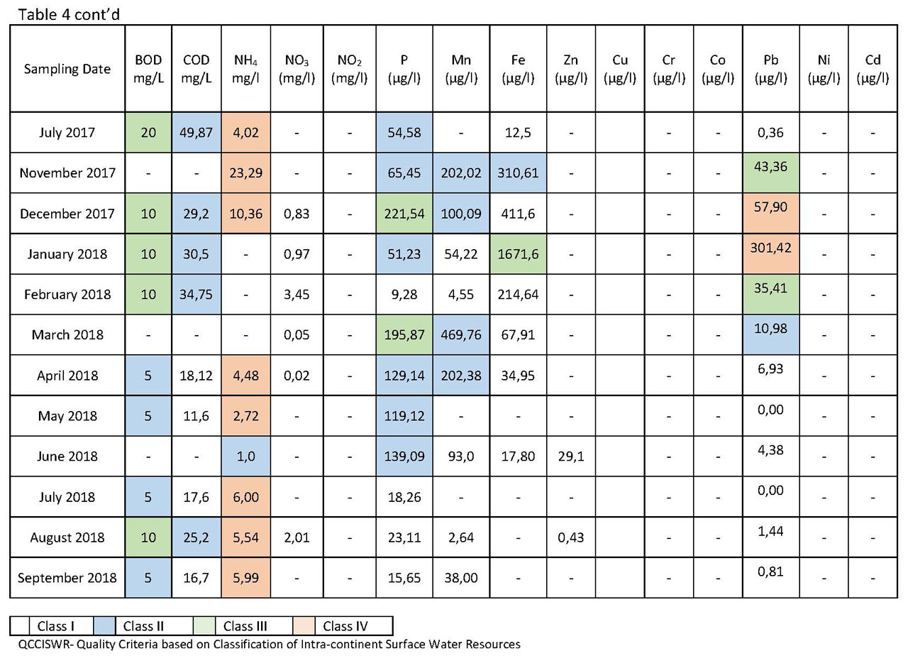
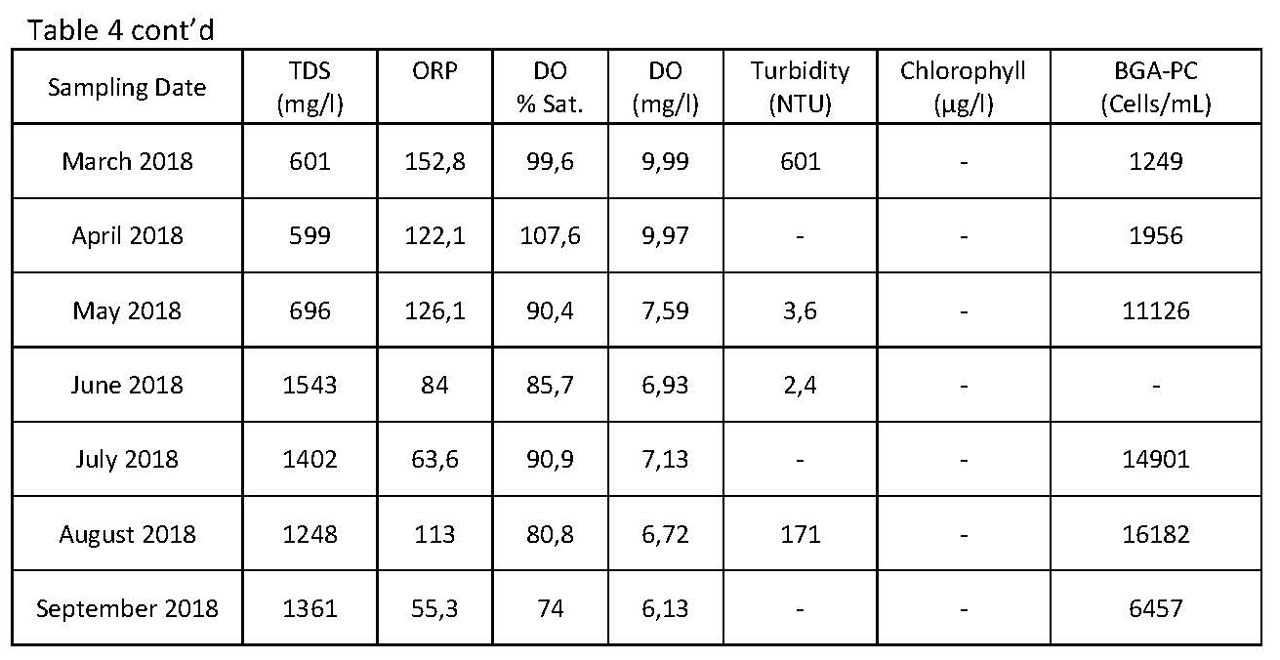
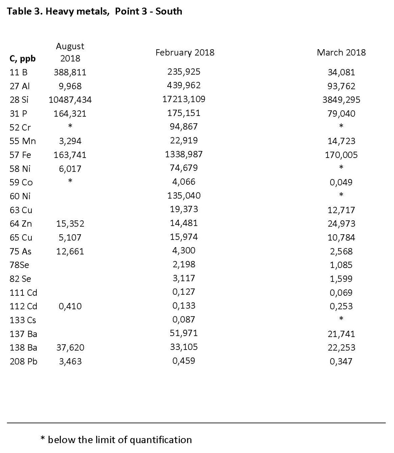
Water samples taken from third sampling point (Table 4):
Water’s salinity was determined to be between 0,531 and 2,708 dS m-1 (Class II and III),
Faecal coliform values were determined to be between 20 and 22600 CFU/100 ml (Classes II-III-IV),
BOD values were determined to be between 5 and 20 mg L-1 (Class II and III), COD values were determined to be between 11,6 and 49,87 mg L-1 (Class I and II).
Regarding nutrients, just like the other two sampling points, only NH-N values were determined to be high (Class IV) while NO3-N ve NO2-N caused no contamination.
Phosphor values were classified as good and average; Mn values were classified as good; Fe values were classified under Class II in November 2017 while determined to have average contamination according to the water sample taken in January 2018; while for the rest of the months, it was classified as high quality water.
No Zn, Cu, Cr, Co, Ni, and Cd were found, and Pb values were classified under Class IV in December 2017 and January 2018.
Some parameters of water samples taken from three different sampling points in Lake Gala were analyzed seasonally, and are shown in the graphics below.
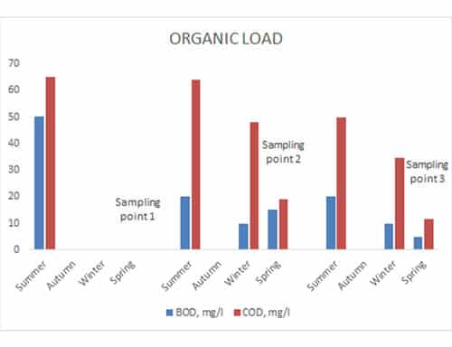
Figure 2. Seasonal graphic of BOD and COD parameters
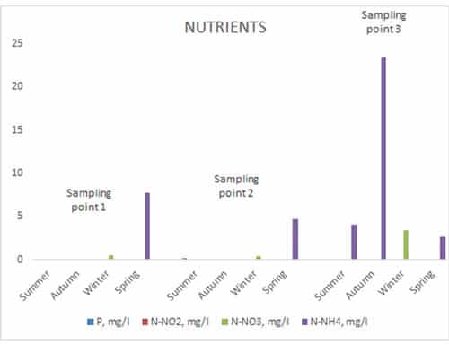
Figure 3. Seasonal graphic of P, HN4-N, NO3-N, and NO2-N parameters
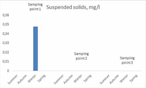
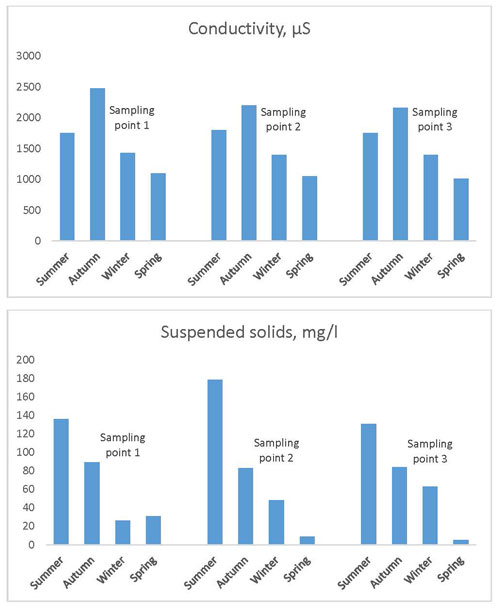
Figure 4. Seasonal graphic of suspended solids (SS)
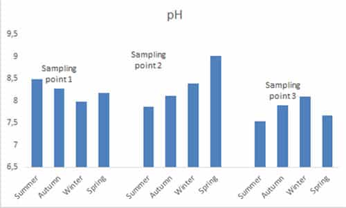
Figure 5. Seasonal graphic of pH values
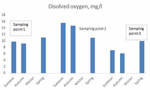
Figure 6. Seasonal graphic of dissolved oxygen values
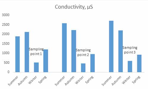
Figure 7. Seasonal graphic of electrical conductivity
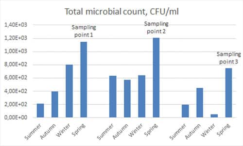
Figure 8. Seasonal graphic of faecal coliform values
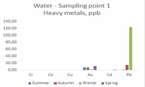
Figure 9. Seasonal graphic of heavy metal values of water samples taken from first sampling point
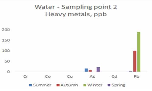
Figure 10. Seasonal graphic of heavy metal values of water samples taken from second sampling point
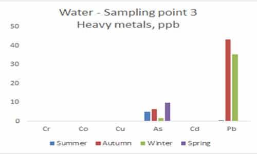
Figure 11. Seasonal graphic of heavy metal values of water samples taken from third sampling point
Evaluation of Lake Gala in terms of water quality:
- Results of analyses on samples from all three sampling points are similar.
- Salinity values vary between 0,185 and 2,708, with an increase observed in salinity during summer months.
- Oxidation parameters are not at a level of concern.
- Regarding nutrients, it is determined that there is only concern with respect to NH-H.
- Lake water is determined to have faecal coliform contamination. As samples were taken from Lake’ shore, intense human and animal activities caused increase in values in some months.
- In some months, Mn, Fe, and Pb contamination was determined.
- No Zn, Cu, Cr, Co, Ni, and Cd contamination was determined.
Conclusions
1.General overview
Lake Gala National Park, located in Counties of Enez and Ipsala in Province of Edirne, and designated as Turkey’s 36th National Park under the Council of Ministers’ Decision as published in the Official Journal dated 05.03.2005, spans on an area of 6.090 hectares, of which 3.090 hectares are wetlands (Big Gala Lake, Small Gala Lake, Pamuklu Lake) and 3.000 hectares are forestlands (skirts of Mount Hisarlı).
Lake Gala National Park is located within the Meriç Delta Wetland which is listed in the List of Important Natural Areas, Important Bird Areas, and Important Plant Areas of Turkey, and designated as Class A international wetland meeting three Ramsar Criteria (Criteria 4, 5, and 6); and it has been evaluated under 2 main parts, i.e. Terrestrial Ecosystem and Aquatic Ecosystem.
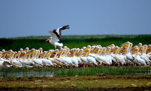
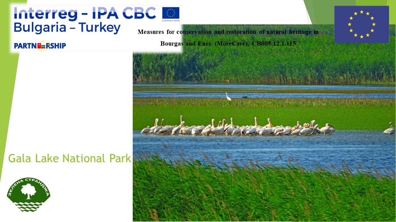
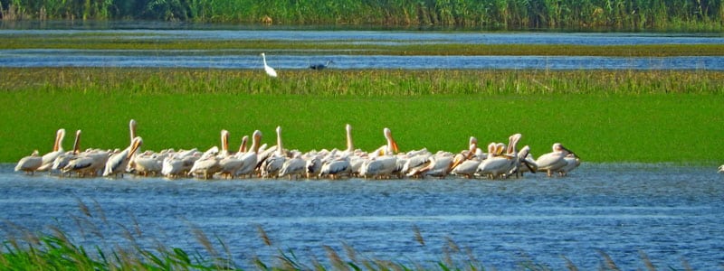
Image 1. Dalmatian Pelican in Lake Gala natural habitat
Lake Gale National Park is located 8km to the County of Enez, 23 km to the County of İpsala, 50 km to the County of Keşan, 155 km to centre of Province of Edirne, and 240 km to Istanbul.
Lake Gala National Park is located in, and one of the largest wetlands of, Lower Meriç Flood Plain, bordering on Ergene Dry Forest–Anthropogenic Steppe Section of Marmara Transition Region and Aegean Subsection (Turkish Pine) of Mediterranean Climatic Area, i.e. the ecological regions of Turkey.
Main resource values of Lake Gala National Park include 3 lakes (Big Gala Lake, Small Gala Lake, Pamuklu Lake), and waterfowls living in reeds there. Among other resource values of the National Park are Mount Hisarlı and its skirts which feature endemic plants. In Mount Hisar, there is a Montpellier Maple Genetic Preservation Forest extending over an area of 60,3 hectares. Genetic preservation forests are strict preservation areas in which any type of intervention is strictly prohibited.
The region where the National Park represents various ecosystems as it is located in a transitional region featuring a wide range of ecosystems, including Mediterranean Shore ecosystems and terrestrial ecosystems.
311 plant species were identified in the Natural Park. 5 of them (Dianthus ingoldbyi, Taraxacum aznavourii, Centaurea polyclada, Dianthus lydus ve Campanula lyrata subsp. lyrata.) are endemic species.
59 taxons which can be used for medical and economic purposes have been identified in the Lake Gala National Park. 22 of such plants can be used for medical purposes while 13 of them can be used as ornamental plants. Species Acer campestre, Pistacia terebinthus, Hedera helix, Xeranthemum annuum, Cornus mas, Quercus cerris, Quercus coccifera, Ficus carica, Rosa canina ve Typha angustifolia are today actively used for economic purposes.
Image 2. A view of Lake Gala Reeds
165 bird species are seen in the National Park, of which 165 are domestic birds, 27 are winter migrant birds, and 90 are summer migrant birds. 16 fish species have been identified, including eel, pikeperch, carp, and northern pike which have high economic value.
Among bird species identified within boundaries of Lake Gala National Park are some rare and endangered species. Species such as White-headed duck (Oxyura leucocephala), White-tailed eagle (Haliaeetus albicilla), Osprey (Pandion haliaetus), Dalmatian Pelican (Pelecanus crispus), Pygmy Cormorant (Phalacrocorax pygmeus) are globally endangered species which are under protection while some other species which include in particular Swans (Cygnus spp.) and Pelicans (Pelecanus spp.) are under risk in the area due to risk they are exposed to in the area. Main threats to such species include killing of pelicans due to their excessive fish consumption, and smuggling of Swans due to high demand for Swans as ornamental animals. Other endangered species in the area include Glossy Ibis (Plegadis falcinellus), Spur-winged Lapwing (Vanellus spinosus), Purple Heron (Ardea purpurea), Black Stork (Ciconia nigra), Ruddy Shelduck (Tadorna ferruginea), Common Shelduck (Tadorna tadorna), and Common Kingfisher (Alcedo atthis).
There are 9 Amphibia (Amphibian) species, 25 Reptilia (Reptilian) species, 1 Erinaceomorpha (Hedgehog) specie, 6 Soricomorph (insectivore) species, 24 Chiroptera (Bat) species, 1 Lagomorpha (Rabbit) specie, 17 RODENTIA (Rodent) 17 species, 9 CARNIVORA (Carnivore) species, and 1 ARTIODACTYLA (hoofed) specie.
Of reptiles represented with 25 species in the National Park and ecological boundaries, there are European Pond Turtle and Striped-neck Terrapin populations, though not very large, which are scattered in water system and along coastal areas.
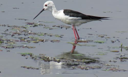
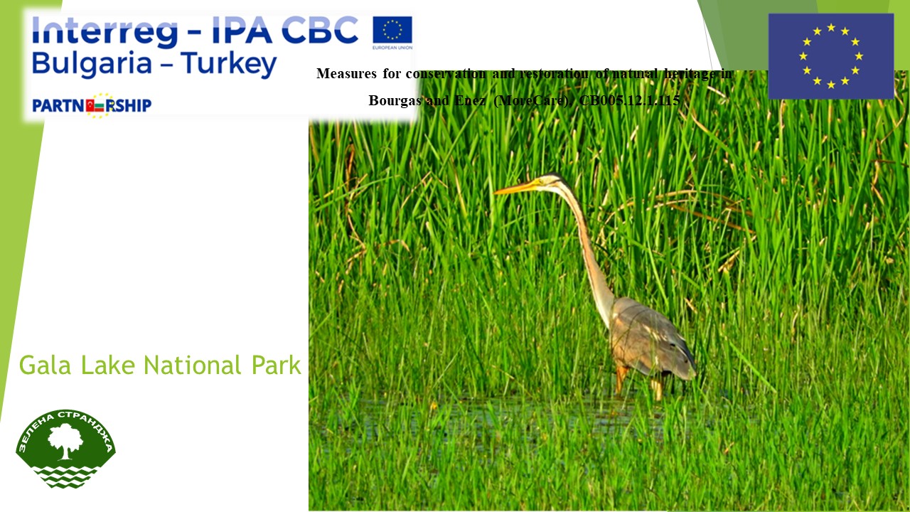
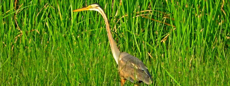
Image 3. Heron Seen in Lake Gala Natural Habitat
Recreational opportunities
Lake Gala has a versatile habitat as it has fresh water resources and wetlands, is close to the sea, has a forest ecosystem in close proximity, meadows, and highlands. The National Park is also located in the north-south migration route of birds in Turkey so it is suitable for bird watching, habitat observation, and nature photography activities. On 15.05.2013, Uzun Develi Development Plan was approved to regulate land development decisions in order to establish a proper preservation–usage balance for the Lake Gala National Park in order to pass it on to future generations as a national heritage. The plan provides for visitor attractions such as a 12km natural walking track, bicycle track, bird watching tower, scenic viewpoints, introduction centre in the Park.
2.According to water quality analyses:
According to results obtained:
Around Lake Gala, there are plant production and animal breeding activities, i.e. rice fields, and cattle breeding in pastures. Lake’s water is a valuable resource for meeting drinking water needs of animals.
Image 4. Rice production next to Lake Gala
Due to intensive agricultural activities carried out around Lake Gala, the Lake is exposed to significant levels of organic and inorganic contamination resulting from flow of some of tail water from paddy fields in İpsala and Keşan regions, and flow of some of Ergene River’s water into the Lake.
As great amounts of chemical composite fertilizers (20-20-0, 18-46-0) are used for rice production around the Lake, the available phosphorus quantity has reached high levels (11,48 mg kg-1-97,36 mg kg-1). Though the phosphorus is washed out of the soil slowly, use of water-soluble fertilizers will enable washing to a certain extent in paddy cultivation where water in the paddy field is circulated continuously.
As paddy cultivation fields are under water most of the year, there are high quantities of available iron and manganese as plant nutrients in the close proximity of lake (0-15 km diameter) (e;15,08 mg kg-1-174,34 mg kg-1, Mn;39,48 mg kg-1-101,84 mg kg-1) (Gürbüz et al.,2018). Quantity of elements in Lake water reaches to high values in some months due to surface and underground feeding, as well as flow of sediments from surrounding areas.
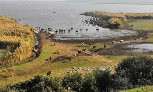
Image 5. Animal Breeding Activities around the Lake
Existence of high quantities of lead (pb) in the Lake water in some months is assumed to be caused by use of agricultural equipments during paddy cultivation, and traffic in the highways in the region.
3.Other problems relating to Lake Gala, and measures required to be taken for such problems
- Though it is prohibited, harvest wastes from fields used for cultivating paddy around the Lake are illegally burnt during winter and spring which deteriorates the air quality.
- Mandatory fertilizing rules based on soil analysis should be imposed for paddy fields in the region in order to prevent use of excessive amounts fertilizers with water-soluble nitrogen and phosphorus content, optimize use of fertilizers, and reduce their impacts on the water quality. In addition, agricultural enterprises should be subject to trainings on good agricultural practices intended to prevent nitrate contamination.
- Regulations should be put into effect for farms around the Lake, and discharge of farm wastes into the Lake should be prevented.
- Efficiency of existing management plan should be improved, management and coordination activities should be in place at basin level, and water quality changes should be monitored and evaluated online in order to ensure continuity of monitoring activities in the Lake, and improve water quality of the Lake.
Report prepared by:
Dr. Ülviye ÇEBİ – Atatürk Soil, Water, and Agricultural Meteorology Research Institute/Kırklareli
Dr. Fatih BAKANOĞULLARI – Atatürk Soil, Water, and Agricultural Meteorology Research Institute /Kırklareli
Dr. Mehmet Ali GÜRBÜZ Atatürk Soil, Water, and Agricultural Meteorology Research Institute /Kırklareli
Dr. Başak AYDIN – Atatürk Soil, Water, and Agricultural Meteorology Research Institute /Kırklareli
You can download the file from the link above.


Project “Measures for conservation and restoration of natural heritage in Burgas and Enez (MoreCare)“, ref: CB005.1.115, „Development of a joint model and an assessment methodology for ecosystem services in Vaya (Burgas) and Gala (Enez) lakes“
LAKE VAYA – MAP
Industrial sources of pollution in the area of Lake Vaya
Легенда:
1 – Industrial areas;
2 – Municipal landfill;
3 – Opencast;
4 – Petroleum;
5 – Kronoshpan;
6 – Waste water treatment plant;
7 – Electro power plant
Ecosystem services in the area of Vaya lake
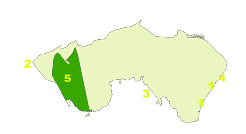
Legend:
1 – Eco zone for fishing;
2 – Ecosystem for fish farming, bird watching, horse riding, organic farming, sports, etc.
3 – Forest;
4 – Rowing base;
5 – Protected area “Vaya”
You can download the file from the link above.
Measures for conservation and restoration of natural heritage in Bourgas and Enez (MoreCare), CB005.12.1.115
“Development of a joint model and an assessment methodology for ecosystem services in Vaya (Burgas) and Gala (Enez) lakes”, CB005.1.12.115/S-4
ECOSYSTEM RESOURSES LAKE GALA
Associate Professor D-r Maria Broshtilova
Eng. Vladimir Dimitrov
ASSOCIATION GREEN STRANDJA
Burgas, November 2018
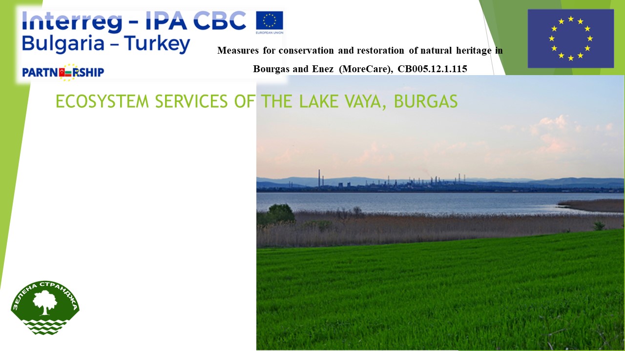
ECOSYSTEM RESOURCES AND SERVICES OF VAYA LAKE, BURGAS
Coordinates – 42.502471, 27.400832
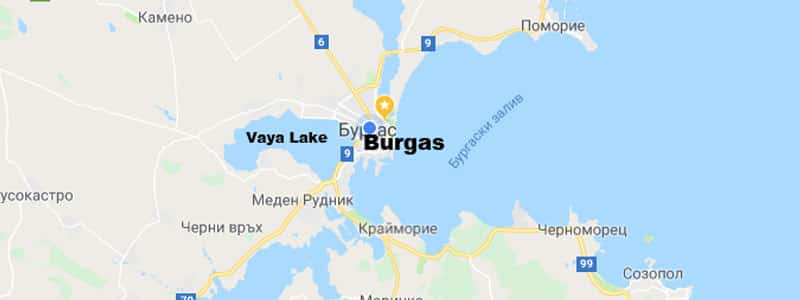
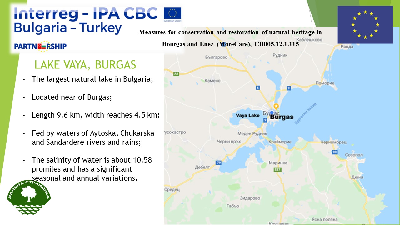
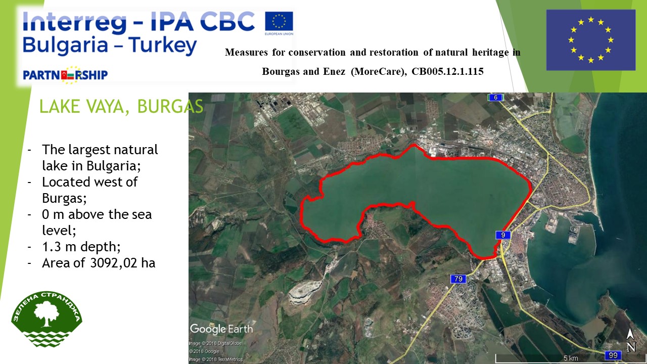
“Burgas Lake” (Vaya) is the largest natural lake in Bulgaria, located in the Black Sea bio-geographic region, the Black Sea area, the South Coast. The lake and its adjacent territories fall in the territory of the city of Burgas, Burgas Municipality.
It is a shallow-water brakish coastal lake – open liman, known under two names – Lake Bourgas and Vaya. It is located to the west of Bourgas, and its entire eastern part rests on the industrial and residential districts of the city. It has a length of 9.6 km west, its width reaches 4.5 km (an average of 2.8 km). The lake itself is at sea level, but its western coast is about 0.2 m and the northern and southern shores reach 15-20 m above sea level.
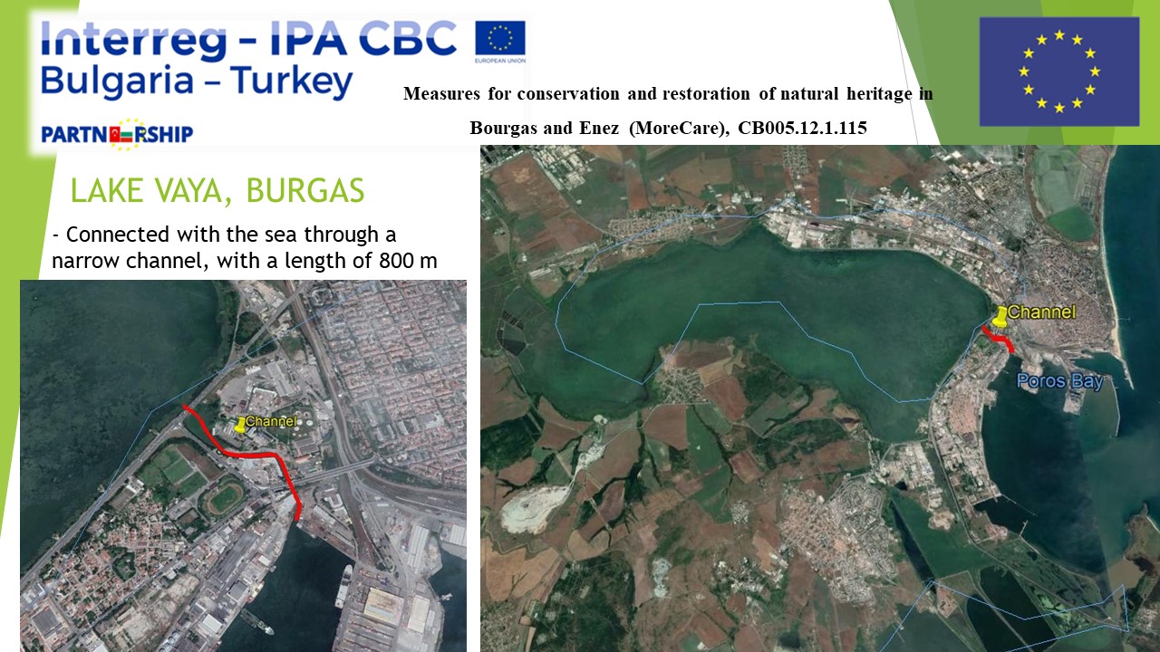
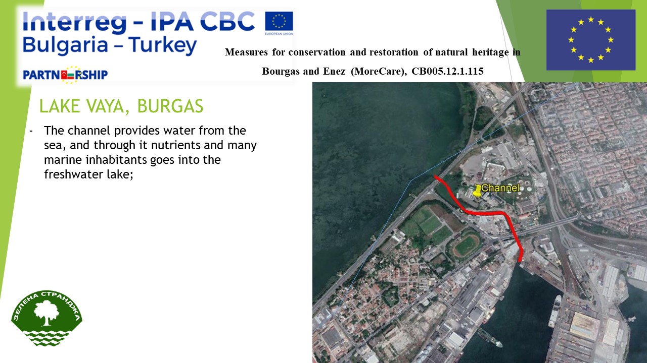
Burgas Lake occupies an area of 3092.02 ha. The total water surface is 2760 ha and the water volume – 19.0 million m3. The lake is connected to the sea through a narrow channel, 350 meters long with a gateway, the cleaning of which in recent years one of the most important challenges is facing the normal functioning of the lake. The channel provides vital fresh water from the sea, with nutrients and many marine inhabitants in the freshwater lake. From the sea is separated from sandy landform, on which today is built an industrial zone and a residential quarter of Burgas. Years ago it has created the biggest problems for the living world of this liman. The depth of the lake reaches up to 1.3 m. The salinity of the water is about 10.58 miles and has significant seasonal and annual fluctuations. With long east winds on the sea, additional salting of a part of the lake takes place. In the western part of Vaya flows the waters of the Aitoska, Sunderere and Chukarska rivers.
The area of the lake is 87%, state –owned, 7% – municipal property and 6% – private property. The water area is an exclusive state property.
In the southwest, the lake is surrounded by smaller ponds – marshes that are densely overgrown with marshy vegetation and fishponds. The lake and the near marshes are the biggest Typa massif in the coutry. The lake shores are all in water plants, mainly Phragmites (Phragmites australis), Typha (Typha angustifolia), Typha with wide leaves (Typha latifolia) and so on, which form large massive in the west and northwest part. Around the lake are wet meadows, halophytic grasslands dominated by Puccinellia (Puccinellia convoluta), grass, mainly bulbosa (Poa bulbosa), pasture Lolium (Lolium perenne), arable land and pastures.
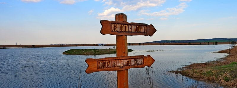
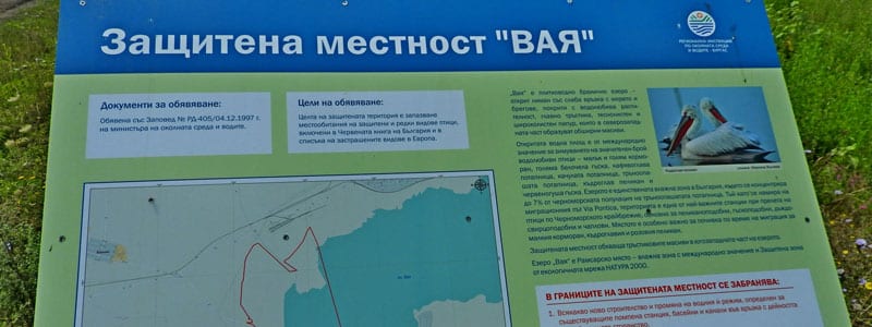
Part of Lake Vaya (12%) is legally protected under national environmental law. In 1997, the Protected Area (PA) Vaya (379.4 ha) was declared for the conservation of endangered bird species, covering the reed massifs in the southwestern part of the lake.
In 1998, the lake was designated a CORINE site because of its European importance for the conservation of rare and endangered bird species, code: F00007600. In 2003, the Burgas Lake was declared a Wetland of International Importance, according to the Ramsar Convention with an area of 2899.9 hectares, including the entire lake aquarium and the channel connecting the wetland with the Black Sea, the territory of the Vaya Protected Site, as and sections along the left bank of the Aitos River and a small stretch southwest of Vaya fishponds. In 2005 the site was declared by BirdLife International for BirdLife (IBA) – IBA BG035. In 2007 IBA “Burgas Lake” was included in the European Ecological Network Natura 2000 as a protected area under the two directives (for the protection of wild birds and for habitats) – Code in the register: BG0000273. The area of the lake Vaya is included in the network of the background and impact zones (stations) of the National Program for Biomonitoring of Bulgaria.
Lake Burgas (Vaya) is a representative ecosystem of the West Black Sea coastal limans, with a high importance for the conservation of a number of rare and endangered species of national, European or world importance. It is part of the Burgas Lake Complex – one of the three most important complexes of wetlands for waterfowl on the Bulgarian Black Sea coast.
Until the present moment, the flora of the Vaya Protected Site and the Ramsar site are set to 77 families and 255 genus and includes 326 species of higher plants. The number of trees and shrubs introduced is high, especially on the eastern shore of the lake and the channel connecting it with the Black Sea. 14 of these spices are included in the Red book of Bulgaria, as 12 of them are in the category “rare”: Silene euxina, Polycnemum heuffelii, Acanthus spinosus, Aeluropus littoralis, Bupleurum flavum, Heptаptera triquetra, Erodium hoefftianum, Halimone pedunculata, Gypsophilia trichotoma, Phalaris tuberosa, Saccharum ravennae Lemna gibba; 2 types in the category “endangered”– Limonium latifoliu and Goniolimon tataricum; 1 type is in the category “disappeared”– Halimone portulacoides; 3 types: Aeluropus littoralis, Limonium latifolium and Goniolimon tataricum are protected with an Order / 718/1989 of the Ministry of environment. One type is included in the Red book of Europe: Goniolimon tataricum. On the territory are found 2 types of Balkan endemics: Heptaptera triquetra and Bupleurum flavum. Three types are in the list of CITES: Orchis elegans, Paeonia peregrina and Ruscus aculeatus. With conservation importance is also the population of the Sternbergia colchciflora, although unprotected, distributed in separate places south of the protected area. There are set total of 57 species of medicinal plants included in the Annex to Art. 1, para. 2 of the Medicinal Plants Act (State gazette, issue 29, 2000).
Until 1956 the number of permanently inhabiting fish species in Lake Burgas is 20, of which only 11 are in the lake. The other species are mostly marine, represented by single specimens in the sea and the mouth of the canal – the triangle orchard, the arterium, etc. 5 species are listed in the list IUCN –Atherina boyeri, Syngnathus abaster, dragonfly (Hippocampus ramulosus), Round goby (Neogobius melanostomus) and Monkey goby (Neogobius fluviatilis). 3 types – eel (Anguilla anguilla), atherina (Atherina boyeri) and three-spined stickleback (Gasterosteus aculeatus) are included in the red book of Bulgaria. Syngnathiformes and Monkey goby are in the list of the Bern convention, 4 species are in the list of CORINE. Due to the changes in the hydrological regime and the composition of the lake waters, after 1970 the lake of Burgas is characterized by a very poor qualitative ihtiofauna. Most of the species currently found are characterized by high adaptability and great resistance to unfavorable conditions. Permanent ichthyofauna is represented by inferior and introduced species such as silver carassius (Carassius auratus gibelo), pseudorasbora (Pseudorasbora parva), gambusia (Gambusia affinis holbrooki), European perch (Perca fluviatilis), Pumpkinseed (Lepomis gibbosus). 7 types of the Red Book, which are found in the lake in 1967 now are gone – six of them due to the change in salt regime (Syrman goby, European sprat, Nine-spine and three-spined stickleback, Caucasian dwarf goby, aterin) and one – oblezat, because of disconnection to the Mandra Dam.
So far eight types of amphibians and 14 species of reptiles have been identified in Vaya. From amphibians: Pelobates syriacus (Pelobates syriacus balcanicus) е включенa в is included in the Red book of Bulgaria and the Red book of Europe; 2 spieces – голям Smooth newt (Triturus cristatus) and European tree frog (Hyla arborea) are included in the International red list (IUCN). 5 species are protected with an Order 729/1986 of the Ministry of environment and waters, 5 are in the list of CORINE, 5 are included in Attachment II and 2 – in Attachment III of the Bern Convention.
From the reptiles, three species are included in the World Red Book – Common tortoise (Testudo graeca graeca), Hermann’s tortoise (Testudo hermanni boettgeri) and European pond turtle (Emys orbicularis). Common tortoise is also included in the European red list. One unique snake for Bulgaria: Four-lined snake (Elaphe quatuorlineata sauromates).
In the area of the lake have been identified about 245 bird species, 9 of which are globally threatened: Pygmy cormorant (Phalacrocorax pygmeus), Dalmatian pelican (Pelecanus crispus), Red-breasted goose (Branta ruficollis), Ferruginous duck (Aythya nyroca), White-headed duck (Oxyura leucocephala), Corn crake (Crex crex), Greater spotted eagle (Aquila clanga), Red kite (Milvus milvus) and Lesser kestrel (Falco naumanni). 67 are included in the Red Book of Bulgaria. 123 species are of European conservation importance (SPEC), as in the category SPEC 1 are included 9 species, in the category SPEC 2 – 26, in SPEC 3 – 69 and in the category SPEC 4 – 43. The site provides suitable habitats for 89 species included in Attachment 2 of the Biodiversity Act, for which special protection measures are required. Of these, 80 are also listed in Annex I of EU Directive 79/409. Since the lake is located on the Via Pontica migration route, it is one of the most important stations of bird migration on the Bulgarian Black Sea coast. Particularly numerous are the pelican-like, fox-like, rain-like and mistletoe birds.
Vaya is the place with the highest concentration in Bulgaria for Great white pelican (Pelecanus onocrotalus) during migration and for Dalmatian pelican (Pelecanus crispus) и White-headed duck (Oxyura leucocephala) during hibernation. As a migratory species in the area is established also Corn crake /Crex crex/. Burgas Lake is of international importance for the hibernation of a considerable number of waterfowl, mainly of Pygmy cormorant /Ph. pygmeus/, Great cormorant /Ph. carbo/, Whooper swan /Cygnus cygnus/, Greater white-fronted goose /Anser albifrons/, Common pochard /Aythya ferina/ и Tufted duck /Aythya fuligula/. Lake Bourgas is the only place in Bulgaria where it concentrates up to 7% of the Black Sea population of Bulgaria White-headed duck /Oxyura leucocephala/. In the winter were also seen the world threatened Dalmatian pelican /P. crispus/ and Red-breasted goose /Branta ruficollis/. The lake is one of the most important places in the country for the preservation of Little bittern /Ixobrychus minutus/. 90 species of breeding birds have been found on the wetland and 8 species have disappeared as such. Vaya is a nesting habitat for the globally threatened Ferruginous duck (Aythya nyroca).
The wetland territory is a “bottleneck” for a large number of migratory birds (day-long predators and water-lovers) from northern Europe (“bottleneck area”).
Until the mid-1970s, the reedbeds of the protected area in the western part of the lake nest a large colony of Pygmy cormorant (Phalacrocorax pygmeus), Eurasian spoonbill (Platalea leucorodia), Glossy ibis (Plegadis falcinellus) and different types of Ardea.
So far, 36 species of mammals have been identified. Of these, 6 species are globally threatened, included in the list IUCN – Eurasian otter (Lutra lutra), European ground squirrel (Spermophphilus citellus), Lesser mole-rat (Nannospalax leucodon), Edible dormouse (Glis glis), Eurasian harvest mouse (Micromys minutus) and Greater mouse-eared bat (Myotis myotis). 6 species are included in the Red Book of Europe Eurasian otter, Greater mouse-eared bat, Eurasian harvest mouse, Jackal (Canus aureus), Eurasian otter and Wildcat (Felis silvestris). European ground squirrel, Greater mouse-eared bat, Lesser mouse-eared bat (Myotis blythii) and Eurasian otter are on the list of the European Habitats Directive. 22 species are listed in the Bern Convention, 4 species – CORINE list. The 9 species of bats established in the territory are included in the list EUROBATS. Eurasian otter and European pine marten (Martes martes) are included in the Red Book of Bulgaria, and another 11 species are protected by Order 1021/1986 of the Ministry of environment.
Lake Bourgas is an extremely important place to feed numerous bat species. The rich fauna of water insects, composed mainly of representatives of the Chironomidae is the main food base of the bat community. It is from a relatively small number of species, but extremely numerous. These are, above all, the two species of the family Vesper bat (Vespertilionidae): Common pipistrelle (Pipistrellus pipistrellus) and Nathusius’s pipistrelle (Pipistrellus nathusii). Nathusius’s pipistrelle, considered a rare species in Bulgaria, is widely distributed and shows very high nutritional activity. The next frequencies are Common noctule (Nyctalus noctula) and Serotine bat (Eptesicus serotinus). The listed species refer to the anthropological complex because in the area of the lake the settlements provide them with the best day shelters. Relatively fewer visitors to the lake area are several species of bats inhabiting forest, rocky or karst areas: Daubenton’s bat (Myotis daubentonii), big or Lesser mouse-eared bat (Myotis myotis/blythii – both types give almost identical ultrasound signals, so their distinction is impossible), Hypsugo savii, Plecotus (Plecotus sp.)., which is explained by their far-flung day shelters.
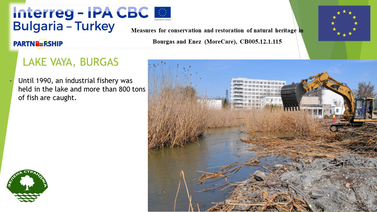
By 1990, a fishing industry had been operating in the lake for nearly 70 years. Only up to 40 years ago it is known for the highest productivity of fish in Europe, it has produced over 800 tons of seasonal fish, with only 150 tons of sea lobster. Over the last few years Burgas Lake has returned to Bulgaria as a source of fish . At present, fishing in the lake. The annual amount is estimated at about 200-250 tons, mainly from silver caraway and significantly less carp. This is largely due to the cleaning of the canal linking the lake with the sea, which allows the penetration of the sea crayfish and other types of fish.
Research of the public opinion about the state of Lake Vaya and the ecosystem services it provides
Local research was conducted through an online poll in the period April – May 2018.
The poll is available at:
https://docs.google.com/forms/d/1NLlquN0D9d4cpaEd9ybPZeY6qqEGH2mo5w1Xl5yMSBc
The questionnaire was filled by 35 persons.
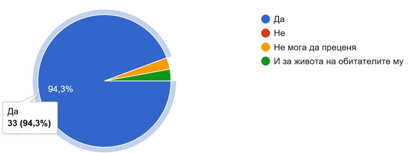
On the first question: “Lake Burgas (Vaya) is the largest natural lake in Bulgaria, part of the Burgas Lake Complex, a protected area with 245 species of birds. It is located within the boundaries of the city of Burgas and is strongly influenced by the human activity. Do you think the lake is important to people’s lives?” 97% of the respondents answered positively, 1 person replied that they could not judge.
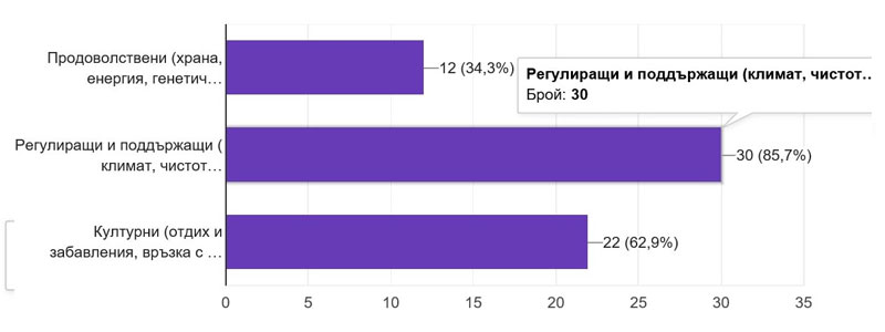
On the second question: “What are the most important ecosystem services (benefits) that the lake provides?” Most of the respondents – 86% mentioned the regulatory and maintenance services. This coincides with the assessment of the ecosystem services on the developed model for lakes Vaya and Gala where it is seen that the indicators of the regulating and supporting ecosystem services have the highest score of points
The third question: “Have you benefited directly from any particular service? If yes – what? “16 of respondents or 46% responded negatively or simply did not respond. Other positive responses include bird watching, fishing, cycling, recreation among nature – all activities belonging to the group of cultural ecosystem services. This is because people mostly appreciate the services they can use to their own choices, while food and regulators are taken for granted. The large number of negative answers to this question is evidence of the incomplete potential of the cultural ecosystem services provided by Lake Vaya.
The fourth question: “Are you interested in developing more cultural ecosystem services in the Lake Vaya area? Describe briefly what.” 80% respond positively, giving suggestions for the development of cycling, hiking, kayaking, ornithology, fishing, family recreation, photography, environmental education. It is noteworthy that 34% of responses raise concerns about the cleanliness of the lake, as well as suggestions or calls for greater environmental responsibility on the part of people and institutions.
On the last question: “Are you interested in developing ecosystem services in the Lake Vaya? What exactly? “The positive answers are only 20%, most of which relate not to the direct organization and provision of some kind of services, but rather to joining activities to clean the lake or participate in cultural ecosystem services.
You can download the file from the link above.
CONTRACT TITLE: Study on the ecological status of the waters of Lake Vaya and providing trainers on environmental protection
REF: RD-02-29-71/ 20.03.2017-S-1
Final Report
Burgas “Prof. Dr. Asen Zlatarov” University
“Prof.Yakim Yakimov” Stр.1,., 8010 Burgas, Bulgaria
…………………………………………
Prof. M. Mitkova, Rector (contractor)
__________________________________________________________________________
Dec 14, 2018
According to the Technical offer the services provided by the tenderer on the basis of contracting authority’s enquiry in the Part A, Point 2, the current Report covers the following components:
A. Study on the quality of waters in Vaya lake
- The activities include monthly water quality analysis at Lake Vaya at three sampling points to obtain data to compare regional differences in water quality in Vaya and Gala lakes.
- Study is aimed at detecting pollutants of a chemical and biological nature, identifying trends in water quality, and determining the degree of influence of nature of pollutants on biodiversity and the possible use of waters for recreational purposes.
- The impact of the waters of the Marine Lakes Channel on the ecological characteristics of the water should be studied.
- The study should be conducted on the basis of reliable data from the certified laboratory ensured by the Contractor.
- Monthly samples of water quality in Lake Vaya at three sampling points should be taken for at least 6 months; The water quality is tested for several physical, chemical and biological parameters, listed in the corresponding chapter;
B. Participation of two lecturers in two 3-days training one in Enez and one in Burgas
- Two 3-day trainings on environmental protection, conservation of habitats and biodiversity will be held one in Burgas for exchange of information on preliminary results, methodologies used for the study in each lake, potential challenges faced by experts/sub-contractors and expectations reg. the final outputs and one in Enez for presenting the final results.
- In this regard the Contractor has to ensure the participation of two lecturers in each training one to present the interim and final study results, and one who is going to present to opportunities for joined actions and cooperation.
- Elaboration of at least 12 presentations.
C. Reporting
Elaboration of interim/ final reports to acceptance protocols for elaborated research, conducted trainings, interpretations. Preparation of applications-presentations, agenda, lists of participants, photos and other supporting documents to the final report
Introduction
Burgas Lake Complex comprises 4 lakes and 3 protected areas. It is one of the most important wetlands on the Bulgarian Black Sea coast and a significant wetland for waterfowl. One of these 4 lakes is Burgas Lake or Vaya. It is the biggest natural lake in the country and it is a subject of the current study.
Vaya lake is a shallow coastal lake – an open lime with a weak connection to the sea through a canal. Its depth can reach about 1.3 m. The water of the lake is characterized by salinity with high seasonal fluctuations. The lake shores are overgrown with waterfowl vegetation, mainly reed. In the northwest part there are fishponds (currently nonfunctioning). The lake is surrounded with wet meadows, as well as agricultural lands and pastures.
Burgas lake (Vaya) have been listed as Ramsar site (2003) under the Ramsar Convention and it is of international importance, particularly as a waterfowl habitat. Due to a unique оrnithological variety Vaya lake has been declared Ornithological important place (1989) by BirdLife International, Corine site, Protected zone within the meaning of the Biodiversity Act (NATURA 2000 site) and Protected area within the meaning of the Protected Areas Act – Protected Site “Vaya” (1997).
Part of the protected area is the largest natural reservoir in Bulgaria. Burgas Lake or Lake Vaya and its water is distributed between two residential areas of Burgas – Upper and Lower Ezerovo. The Lake occupies 2,899.9ha, with salty waters of a depth of 1.5m due to its relationship with the Black Sea (it is linked to it via a canal). It not only provides a constant flow of saltwater, but it also provides a saltwater fish lake. The freshwater comes from the rivers of Aytoska, Sandardere and Chukarska that flow in the western part. The lake is separated from the sea with a sandbar where now the industrial zone of Burgas is. In the northeastern part of the lake, it is surrounded by small ponds (marshes that are overgrown with dense marsh vegetation and abandoned fishponds).
Burgas Lake sited at the western coast of Burgas Bay, Black Sea, Bulgaria. The lake is separated from the shore by wide strips of beaches. The wide and very shallow lagoon, into which the Aitoska River and small rivers Synyrdere and Chukarska flow. Length of 9.6 km and a width of 2.5 to 5 km. area—27 km“ the country’s largest sea lake. Prior to construction of the canal linking the lake with the sea, in summer its salinity was very much like that of the sea and even exceeded it. After the control locks were built and fresh water from Mandra Lake Storage Reservoir was supplied, in summer, the water and chemical regime of B.L. improved. Carp is common in the lake. It is one of the most productive lakes.
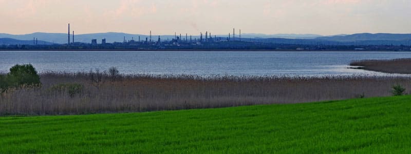
There have been significant changes in lake condition during the last 50-60 years. It is located in close proximity to the Burgas refinery which leads to severe pollution of the lake’s waters in the first years after it was put into operation. The lake bottom is characterized by a very thick sludge layer which is a prerequisite for retaining a number of potentially dangerous substances (such as petroleum products). Shallowing and equalizing of the bottom has been reported which may lead to release of these accumulated in the sludge substances. Another important issue is the disturbed natural connection with the sea leading to a reduction in total and open water as well as a drastic reduction in salinity (from 18‰ in 1958 to 3‰ in 1968). These changes in water quality leads to a change in the type and quantity of fish stocks and thus in both the food base of many waterfowl and lake ecosystem generally.
Another major issue is the strong anthropogenic pressure due to the proximity of the lake to the city, large residential complexes and industrial zones. As a result, both purified and untreated water flow into the lake. On the east coast there is a major road which is another prerequisite for waste disposal. The intensive use of mineral fertilizers and pesticides over the years in surrounding agricultural lands leads to water pollution and accelerated eutrophication.
Due to the international importance of Vaya Lake it is essential to maintain high water quality. The overall condition of the lake is of great significance to conservation and restoration of natural heritage. In order to fulfill this goal, the project sets activities related to detecting pollutants of a chemical and biological nature, identifying trends in water quality, and determining the degree of influence of nature of pollutants on biodiversity.
Reporting
I. Study on the quality of water in Vaya lake
Activities include monthly water quality analysis at Lake Vaya at three sampling points to obtain data to compare regional differences in water quality in Vaya and Gala lakes. Study is aimed at detecting pollutants of a chemical and biological nature, identifying trends in water quality, and determining the degree of influence of nature of pollutants on biodiversity and the possible use of waters for recreational purposes.
The impact of the waters of the Marine Lakes Channel on the ecological characteristics of the water was under study. The study is conducted on the basis of reliable data from laboratories ensured by the Contractor. Monthly samples of water quality in Lake Vaya at three sampling points are taken within 9 months; the water quality is tested for the following physical, chemical and biological parameters, as follows:
- Total Suspended Solids (TSS)
- Turbidity
- pH
- Dissolved Oxygen
- Electrical conductivity
- BOD5
- COD
- P-PO4
- Total N
- NO3 – N
- NH3 – N
- NO2 – N
- Phosphorus
- Oil products
- ICP to determine the content of heavy metals (in sediment and water column)
- GC to determine the content of specific organic pollutants (in sediment and water column)
- Chlorophyll A for the determination of phytoplankton
- Microbial number (count)
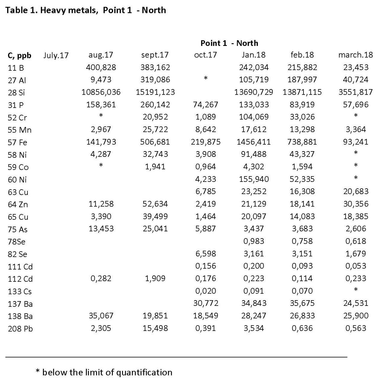
The sampling points are specifically selected in order to cover all kinds of potential pollution sources. Sampling point 1 (North) is located at the point of discharge of Burgas WWTP effluents. Sampling point 2 (Center) is in close proximity to the lake-sea channel and sampling point 3 (South) is chosen as an area with the lowest anthropogenic pressure. Monthly samples for determination of water quality in Lake Vaya are taken at the three sampling points for period of 9 months. The main results are given in Tables 1-4.
Generally, there were no significant differences of the measured parameters of the three test points. As expected in summer and autumn there is a higher salt content of water (presented as conductivity) which decreases in winter and spring. This process can be explained by the concentration of suspended solids in the water (with the same profile).
The decrease observed in the cold months is due to increased rainfall, reduction in sunshine, ion content and nutrients in the water, which is confirmed by the BOD and COD values (again higher in the summer and autumn and lower in winter and spring). These data are a clear indicator of the ability of lake to self-clean.
The same profile is observed with dissolved oxygen, which increases with lowering of temperature. The measured pH is within the optimum limit for water bodies. Increased local microbial concentration has been reported in late autumn. We tend to conclude that it is not a result from ongoing processes and it may be an analysis misdoing at this exact sampling point.
The ratio of the measured forms of nitrogen (nitrite, nitrate and ammonia) shows decaying and natural processes as well as complete nitrification of the water basin. The low nitrate values indicate limited anthropogenic pressure in regard to this indicator. This means that the fertilization of agricultural lands is not that intense and does not lead to environmental pollution.
The total nitrogen content varies depending on the season. The same applies to the amount of phosphorus reported which profile indicates human activity. Migrating birds also have a share in the high phosphorus values due to their rich in phosphorus guano (the migration period corresponds with an increase in the measured phosphorus contend).
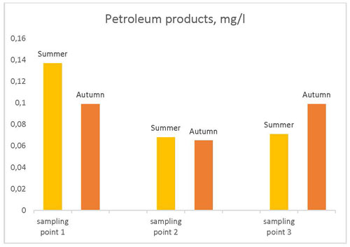
The measured chlorophyll values are within the upper limits, indicating a risk of eutrophication. Low concentrations of petroleum products were established and confirmed by an external accredited laboratory.
Surprisingly, because the closeness of the lake to the Petrochemical industry along Burgas, the concentrations of petroleum products were found to be very low in all seasons, 0.07 – 0.014 mg/l.
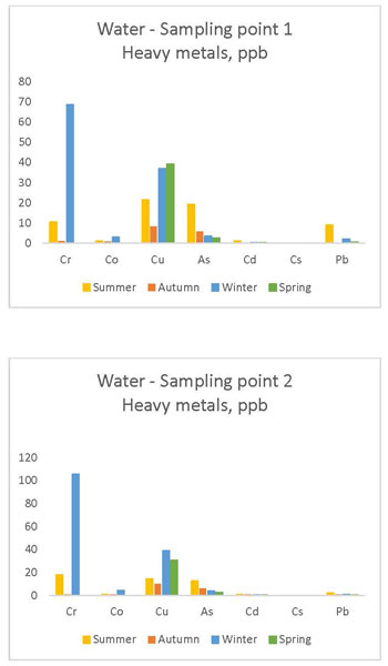
The content of heavy metals was determined both in liquid and sediment samples. As the heavy metals are toxic and at higher levels pose health risk, it is necessary to study their quantitative changes of their presence in Burgas lake water and sediments. Therefore, the purpose of the present work is to observe the changes of heavy metals content within the period of study. The data obtained show an background concentration of all heavy metals studied within 5-40 ppb, with one exclusion for Chromium which reaches in levels above 100 ppb. In all samples the base line concentrations are below the permissible level.
Discussion related to the results obtained
As it was mentioned in the chapter above the sampling points were selected in order to cover the potential pollution changes in all area of the lake and the main sources of pollution, namely Burgas WWTP ( Sampling point 1 North); the sea channel (Sampling point 2 Center) and the area of lowest anthropogenic pressure , point 3 South). Based on the monthly samples for determination of water quality in Lake Vaya taken in a period of 9 months it was found that the measured parameters in the three points of sampling do not differ significantly, so, the water constituents are more or less equal in all lake’s sites. This could be accepted as a proof that there is no momentum high ecological pressure from a single source of pollution.
Regarding the single water quality parameters, the following discussion can be made:
Water salinity
As it could be expected the salinity in summer and autumn is higher (shown by the conductivity measurements) and corresponding decrease in winter and spring base on the higher evaporation during the warm months. The decrease observed in the cold months is due to increased rainfall, reduction in sunshine, ion content and nutrients in the water, which is confirmed by the BOD and COD values (again higher in the summer and autumn and lower in winter and spring).
Total suspended solids
The data obtained for the fluctuation of TSS (total suspended solids) can be explained by the higher extent of diffusion during the summer/autumn time bringing some suspended solids of organic and inorganic nature from the bottom to the upper layer.
Dissolved oxygen (DO)
The view about DO is very typical as it increases with lowering of temperature. Besides the level in summer period, the DO observed is quite high with values exceeded 9 mg/l. Such results show that the processes as aerobic assimilation and nitrification (O2 consuming processes) are not governing the whole self-cleaning process of Burgas Lake. The stable values for pH are also an evidence for a slow going biological nitrification.
Organic matter content
The measured values of BOD and COD show very high distinction for the cold and warm periods. In summer time the BOD and COD values are high which can be attributed to larger effects of diffusion and turbulence of the bottom sludge during this period. Obviously, higher TSS leads to high values of dissolved organic matter.
Nutrient content
The content of P is in the range of 0.1-0.2 mg/l without high deviation through the period of the study. The level of measured forms of nitrogen (nitrite, nitrate and ammonia) shows very low content of all species and almost complete nitrification of ammonia. As it was mentioned above the low level of nitrates is an indication of limited anthropogenic pressure both from human activities and fertilization of agricultural lands around Lake Burgas.
Heavy metals
The metal contend in both types of samples, in water and in sediments, correspond to the emission limits according to Ordinance №6/9.11.2000 for permissible standards for the permissible content of harmful and dangerous substances in waste waters discharged into water bodies. However, the values are close to the requirements set in Ordinance №4/14.09.2012 for the characterization of surface water. We tend to say that this may be a result from the massive lake pollution from the late ’60 to the early ’80. Despite the fact that the lake has not been fully recovered from that damage the measured values of metals and petroleum products, as said above, are within the emission limits according to Ordinance №6 and there is no immediate harm for the aquatic flora and fauna of the lake.
As a Lake, Vaya water quality is preset in Ordinance №4 by Bulgarian Ministry of Environment and Water. All measured values are interpreted according the respective regulation and in respect with the observed data a good condition of the lake is reported. The ongoing processes follow the natural circle and the processes of self-purification are sufficient to maintain its ecological state. (Data presented with a color code: yellow for summer, orange for autumn, blue for winter, green for spring).
Conclusions
Vaya Lake as shallow brackish coastal lake has an open firth with a small connection to the sea and with fringe vegetation along the banks. It is connected to the sea through a channel with a sluice, whose cleaning in recent years has been one of the most important challenges for the normal functioning of the lake. The channel carries fresh water from the sea which is of vital importance and with it many nutrients and sea creatures into the otherwise largely freshwater lake.
The open water area predominates in the lake and in some places it is 1.3 m deep. The shores are covered with a strip of fringe vegetation, mainly reed and bulrush, which in the western and northwestern parts form large massifs.
Burgas Lake is a part of the Burgas lakes complex – one of the three most significant wetland complexes for the gathering water birds on the Bulgarian Black Sea coast. In the area of the lake there are 245 bird species, 71 of which are included in the Red Book of Bulgaria. 105 of all the species occurring here are of European conservation importance. 9 of them are globally endangered species. The area provides suitable habitats for 89 species included in Annex 2 of the Law on Biological Diversity which require special protection measures. Since the lake is on the migratory route Via Pontica, it is one of the most important stations in bird migration along the Bulgarian Black Sea coast. Particularly numerous are pelicans, geese, shorebirds and herons. The lake is particularly important as a resting place during passage for the Dalmatian pelicans and the pink pelicans, as well as for the pygmy cormorants. There are years when Vaya Lake hosts over 20 000 pelicans resting on their migration route. The globally endangered corncrake has also been seen as a migratory species in this area.
Burgas Lake is of international importance for the wintering of a significant number of water birds, mainly little cormorants, great cormorants, whooper swans, white-fronted geese, pochard duck and tufted ducks. Burgas Lake is the only place in Bulgaria where up to 7% of the Black Sea population of white-headed ducks gathers. In winter you can see here the globally endangered Dalmatian pelican and red-breasted goose. The lake is one of the most important places in the European Union for the preservation of the little bittern which nests here.
The lake is subjected to high anthropogenic pressure due to its proximity to the densely populated city of Burgas, large industrial facilities and complexes, as well as the unrestricted and unsupervised access of people to areas outside the protected areas. Burgas Lake is affected by all human activities which may lead to a change of the water regime or water quality of the wetland. It is also affected by the accelerating development of the city. In former years the lake was contaminated with petroleum products, phenols and other chemicals from the nearby oil refinery. The intensive use of pesticides and fertilizers in the surrounding agricultural land lead to pollution and accelerated eutrophication of the water basin. In recent years there has been an increase in the amount of disposed waste and the cleaning activities in the city. Construction and domestic waste has illegally been disposed of in many places around the lake, especially on its northern shores. The water basins in the northeastern part of the lake are filled with dirt and at this stage 80% of them are almost entirely destroyed.
Wastewater from the northern and southern industrial areas of the city flows into the lake after passing through a treatment plant. Significant amounts of wastewater flow into the lake from the villages of Gorno and Dolno Ezerovo, as well as from some enterprises in Burgas. The changes in water quality lead to changes in the type and quantity of fish stocks and thus of the food base of a large number of water birds. The areas around the lake are being polluted and are continuously being built up. The channel connecting the lake with the sea is almost entirely silted and free passage of fish through it is very limited. The international road leading to the southern state border along the east coast contributes to the waste and causes noise pollution.
On the other hand, Vaya offers a good opportunity for the residents of Burgas, when leaving their homes to find themselves among, to some extent, wild nature, to be able to explore it, to use its resources and to enjoy it. Along the shores of the lake there are popular and well-established places for fishing, which attract fishermen. Burgas Lake is a place of interest for photographers who are attracted by the rare and interesting species of birds. In the very near future, as part of the project “Life for Burgas Lakes” of the Bulgarian Society for the Protection of Birds, the pier near the former farm yard in Dolno Ezerovo will be rebuilt. This will provide an opportunity for boat trips and bird watching directly from the lake.
Vaya Lake is a liman and recently it is mixooligohaline with fluctuating halinity due to a siltated channel connection with the Black Sea. The lake is located on the ‘Via Pontica’ ornithological migratory route and is important for the conservation of rare and endangered species of national, European and global significance. The lake is a Ramsar site, a protected area and Natura 2000 site, included as critically endangered in the Red List of Bulgarian Wetlands. During the last decades Vaya has undergone significant changes due to different anthropogenic factors, which disturb the water balance of the lake and lead to introduction of biogenic elements in the wetland with a negative effect on the chemical composition of the water with impacts on the flora and fauna of the aquatic ecosystem.
Even the high anthropogenic pressure on the lake, the results obtained show an improved characteristic of lake water studied in respect of nutrients, organic matter content (BOD and COD) and petroleum products. It is a good prerequisite for further water quality improvement based on the opening the sea-lake channel, which cleaning in the last year has been one of the most important challenges for the normal functioning of Burgas Lake.
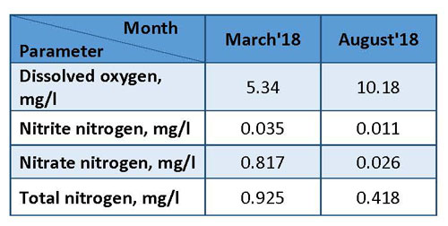
Still, there are efforts to be made and measures to be taken to minimize or even completely eliminate anthropogenic pressure in the future. Good indicator for going on this path is the obtained results after the cleaning of the lake-sea canal. In order to observe the effect of this action in full extent a longer period is needed – more than a year. Nevertheless, simultaneously with the process of cleaning of the canal were taken samples for analysis and there is significant change and progress in some water parameters. The results show (the Table below) that at the end of the summer of 2018 the concentration of dissolved is increased 1.9 times, i.e. the O2 consumption is considerably decreased. Evidently, it shows indirectly a low organic matter load of the lake. The later can be attributed to the fresh sea water coming through the channel. In addition a decrease of measured values of nitrite-nitrogen by 3.2 times, nitrate-nitrogen by 31.4 times and total nitrogen by 2.21 times is observed. These results can be explained by the positive influence of cleaning/opening of the channel to the Burgas bay Black sea water.
Further Environmental Impact
The cleaning of the lake-sea canal and restoration of lake-sea connection is expected to have further beneficial impact on the environmental conditions of Lake Vaya. The above measures undertaken by the Burgas Governmental authorities could have favorable effects are expected to lead to the following effects:
- Normalization of the hydrological regime of the lake and gradual restoration of water salinity to the natural state of the lake as dated in 1960’s;
- Restoration / improvement of the habitat of the inhabitants of the lake;
- A positive change of the species and quantity of the fish stocks resulting in enrichment of food base of many water fowls;
- Restoration of the usual fauna and respectively increasing and improving the lake biodiversity;
- Restoration of the natural state of the lake.
II.Participation in two trainings on environment protection
Two 3-day trainings on environmental protection, conservation of habitats and biodiversity were organised. The training held in Burgas (9-11. Oct. 2017) includes exchange of information on preliminary results, methodologies used for the study in each lake, potential challenges faced by experts/sub-contractors and stakeholders. The event Agenda is attached as an Annex. In addition a WORKSHOP was carried out on 7-8 Oct. 2017 about the activities related on environmental protection, conservation of habitats and biodiversity Vaya Lake, district Burgas, Bulgaria and Gala Lake District Enez, Turkey in the frames of project “Measures for conservation and restoration of natural heritage in Burgas and Enez” (MoreCare), CB005.12.1.115. The corresponding agenda is given in an Annex.
The following reports (12) have been presented at the training held in Burgas (9-11. Oct. 2017):
Доклади (Д)
Д1.Цели, обхват и теми на обучението – Проф. В. Ненов
Д2. Езерото ВАЯ и влажните зони в област Бургас – обща информация и характеристика – доц.д-р Х. Йеменджиев
Д3.Стратегии за мониторинг и оценка на качеството на водите – Проф.В. Ненов
Открита дискусия и представяне на специфични примери Open discussion and specific case studies – всички участници
Д4. Природен статус на ез. Вая. Отговорни ведомства и екологично състояние на езерото – инж.Т.Манолова, РИОСВ
Д5. Езеро Вая като част от екологичната мрежа Натура 2000 – инж.М. Ярмова, РИОСВ
Д6. Влияние на туризма върху състоянието на околната среда и водните екосистеми – Маг.С. Енилова, БРТА
Д7.Процеси на масопренасяне в езерaта – г. ас д-р И. Чобанов
Д8. Оценка на екосистемните характеристики и биологичното разнообразие – доц.Х. Йеменджиев
Д8. Дейност, практики и резултати от мониторинга на околната среда в РИОСВ – Бургас – д-р Т. Михалев Изпълнитела Агенция, МОСВ
Д9. Доклад на резултати от мониторинг на езеро Вая в летния период на 2017-та година – Проф.В. Ненов
Открита дискусия и представяне на специфични примери – всички участници
Д10. Оценка и моделиране на поддържащия капацитет и потенциала за развитие на аквакултури – доц. Х. Йеменджиев
Д11. Методи за оценка на риска от наводнения. Източници на информация, обработка на данните и приложение на Географски информационни системи (ГИС) – доц. Х. Йеменджиев
Д12. Биогенно замърсяване на влажните зони и черноморско крайбрежие в регион Бургас – проблеми и превенция –Проф. В. Ненов
Лектори:
Проф. д-р Валентин Ненов – Университет „Проф. д-р Асен Златаров“ Бургас
Доц. д-р Хюсеин Йеменджиев – Университет „Проф. д-р Асен Златаров“ Бургас
Соня Енилова – Бургаска регионална туристическа асоциация
Таня Манолова – РИОСВ Бургас
Милена Ярмова – РИОСВ Бургас
Гл. ас. д-р Иван Чобанов – Университет „Проф. д-р Асен Златаров“ Бургас
Д-р Тодор Михалев – РИОСВ Бургас
You can download the file from the link above.
European Union Ministry of national authorities the task of carrying out the Interreg-IPA Bulgaria – Turkey Cross-Border Cooperation Program Evaluation first call for proposals is important CB005.1.12.115 “the needs of the natural heritage in Burgas and Enez and needed by the restoration (MORE CARE)” Lake Gala ‘ To periodically review.
FEBRUARY 2019
| 7.02.2019 14:29 | pH | 769.421 |
| 7.02.2019 14:29 | Blur | 0 |
| 7.02.2019 14:29 | Temperature | 8.3 |
| 7.02.2019 14:29 | Status | 1 |
| 7.02.2019 14:29 | Conductivity | 1543.88 |
| 7.02.2019 14:29 | Oxygen | 375.519 |
| 7.02.2019 16:54 | pH | 771.307 |
| 7.02.2019 16:54 | Blur | 0 |
| 7.02.2019 16:54 | Temperature | 8.3 |
| 7.02.2019 16:54 | Status | 1 |
| 7.02.2019 16:54 | Conductivity | 1519.48 |
| 7.02.2019 16:54 | Oxygen | 42.838 |
APRIL 2019
| 9.04.2019 10:37 | pH | 747.357 |
| 9.04.2019 10:37 | Blur | 164.282 |
| 9.04.2019 10:37 | Temperature | 15.1 |
| 9.04.2019 10:37 | Status | 1 |
| 9.04.2019 10:37 | Conductivity | 1472.05 |
| 9.04.2019 10:37 | Oxygen | 206.875 |
| 9.04.2019 17:30 | pH | 755.612 |
| 9.04.2019 17:30 | Blur | 269.835 |
| 9.04.2019 17:30 | Temperature | 17.2 |
| 9.04.2019 17:30 | Status | 1 |
| 9.04.2019 17:30 | Conductivity | 1463.17 |
| 9.04.2019 17:30 | Oxygen | 492.132 |
JUNE 2019
| 8.06.2019 09:31 | pH | 730.984 |
| 8.06.2019 09:31 | Blur | 252.283 |
| 8.06.2019 09:31 | Temperature | 24.5 |
| 8.06.2019 09:31 | Status | 1 |
| 8.06.2019 09:31 | Conductivity | 1992.92 |
| 8.06.2019 09:31 | Oxygen | 0 |
| 8.06.2019 14:35 | pH | 726.639 |
| 8.06.2019 14:35 | Blur | 0 |
| 8.06.2019 14:35 | Temperature | 27.6 |
| 8.06.2019 14:35 | Status | 1 |
| 8.06.2019 14:35 | Conductivity | 1990.52 |
| 8.06.2019 14:35 | Oxygen | 0.143946 |
AUGUST 2019
| 4.08.2019 08:41 | pH | 762.691 |
| 4.08.2019 08:41 | Blur | 0 |
| 4.08.2019 08:41 | Temperature | 25.8 |
| 4.08.2019 08:41 | Status | 1 |
| 4.08.2019 08:41 | Conductivity | 1792.49 |
| 4.08.2019 08:41 | Oxygen | 0.0450857 |
| 4.08.2019 13:49 | pH | 765.572 |
| 4.08.2019 13:49 | Blur | 0 |
| 4.08.2019 13:49 | Temperature | 25.4 |
| 4.08.2019 13:49 | Status | 1 |
| 4.08.2019 13:49 | Conductivity | 1788.23 |
| 4.08.2019 13:49 | Oxygen | 0 |
OCTOBER 2019
| 2.10.2019 08:03 | pH | 752.698 |
| 2.10.2019 08:03 | Blur | 468.311 |
| 2.10.2019 08:03 | Temperature | 20.9 |
| 2.10.2019 08:03 | Status | 1 |
| 2.10.2019 08:03 | Conductivity | 1775.97 |
| 2.10.2019 08:03 | Oxygen | 0.0263349 |
| 2.10.2019 13:22 | pH | 763.328 |
| 2.10.2019 13:22 | Blur | 25.64 |
| 2.10.2019 13:22 | Temperature | 19.9 |
| 2.10.2019 13:22 | Status | 1 |
| 2.10.2019 13:22 | Conductivity | 1706.8 |
| 2.10.2019 13:22 | Oxygen | 0.033969 |
NOVEMBER 2019
| 13.11.2019 13:07 | pH | 758.487 |
| 13.11.2019 13:07 | Blur | 422.835 |
| 13.11.2019 13:07 | Temperature | 28.Mar |
| 13.11.2019 13:07 | Status | 1 |
| 13.11.2019 13:07 | Conductivity | 676.388 |
| 13.11.2019 13:07 | Oxygen | 0.0833023 |
| 13.11.2019 14:06 | pH | 756.907 |
| 13.11.2019 14:06 | Blur | 337.194 |
| 13.11.2019 14:06 | Temperature | 27.Tem |
| 13.11.2019 14:06 | Status | 1 |
| 13.11.2019 14:06 | Conductivity | 689.716 |
| 13.11.2019 14:06 | Oxygen | 0.0819568 |
Measures for conservation and restoration of natural heritage in Bourgas and Enez (MoreCare), CB005.12.1.115, “Development of a joint model and an assessment methodology for ecosystem services in Vaya (Burgas) and Gala (Enez) lakes”
POSSIBILITIES FOR DEVELOPMENT OF ECOSYSTEM SERVICES IN THE REGION OF THE LAKES VAYA (BURGAS) AND GALA (ENEZ)
Association Green Strandja
Burgas, November 2018
In general, ecosystem services are the benefits that natural ecosystems provide to humans. Even if we do not realize, these services exist and we are continually taking advantage of them. Our life is directly connected and dependent on ecosystem resources. The way we use, manage and protect it is in direct dependence on the footprint we leave on nature, the sustainability and nature of our model of life.
1 Lake Vaya
1.1 Human impact
Since its emergence to this day and especially during the last 50 years, Vaya lake is subjected to strong anthropogenic pressure and undergoes significant changes, among which the most important are splintering, combined with bottom leveling, reduction of total and open water space, drastic reduction of salinity and especially heavy pollution with petroleum products. Over the last few years, with the presence of large-scale agricultural machinery and subsidized area farming in the country, problems with the transfer of soil sediments and agricultural fertilizers into the lake’s waters are intensifying dramatically. The management of the reedbeds along the banks of the basin is also of great importance for preserving the open water area required for feeding and resting the birds.
Deterioration of the quality of the waters of Burgas Lake is a serious threat to the survival of the bird and fish food base. In the 1960s, the lake was already highly eutrophic to hypertrophic. After heavy oil contamination in 1967 and then severe blooms of blue-green algae, impoverishment of the upper flora, and massive development of the Stuckenia pectinata (Potamogeton pektinatus). Since 1962, toxic phenomena have been recorded, followed by fish pestilence. Severely toxic seaweed strains, which are dangerous to animal dwellers on the lake, appear. The thick layer at the bottom permanently retains pollutants and mud analyzes even in 1996, showing that it is still burdened with petroleum products. According to Order № RD-272 / 03.05.2001 of the Ministry of Environment and Waters, the design category of surface water in Vaya lake is the second category.
According to the National Plan for the Protection of the Most Important Wetlands in Bulgaria 2013 – 2022, the general condition of the wetland is unsatisfactory, with a tendency to deterioration of bird conservation conditions. The common threats are: extremely strong anthropogenic pressure – flooding of wetlands and buildings, pollution with petroleum products, chemicals and solid household waste, excessive catches of fish and the use of gears that are dangerous to birds, poaching / fish hunting with illegal means – networks lead to a reduction in the fish fauna of the basin, the same is done even during the spawning period of the fish, victims become very rare and endangered species, birds and reptiles/, poaching also causes anxiety among species that nest, feed or rest on the lake, a worsened connection of the lake with the sea, the presence of dangerous for the birds power lines, plans for construction of wind farms.
The specific threats to the ornithofauna are: anxiety, illegal shooting; deterioration of the food base; destruction of power lines around the lake, lack of nesting places; pollution; excessive shooting; use of chemical preparations in agriculture. The specific threats to fish and herpetophanes are: overfishing, introduction of non-native fish species; deforestation; destruction of deciduous vegetation; herbicide contamination, pesticides, burning during the breeding season.
Nowadays in the liman are infused waste waters from the northern and southern industrial zones of Bourgas after passing through the established purifynig plants, but the untreated waters of the Aitoska River also flow. The waters come from the sewage sludge deposits of the city of Burgas as well as from the quarry for inert materials near Gorno Ezerovo. The annual report of the Burgas Regional Environmental Agency for 2016 shows an excess of the standards regarding the aluminum content and eutrophication processes, as well as the deterioration of the parameters compared to the previous year in terms of ammonium and nitrite nitrogen.
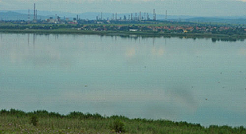
The noise pollution also affects negatively – its sources are the main road that runs through the eastern and northern shores of the lake, the low flying planes landing at Burgas airport, large industrial enterprises. The existence of a road network near the shores of the lake is also a reason for a large part of the household waste.
By 2013, in the eastern part of the lake rans a quarry for inert materials extracted by pumping from the bottom of the lake. As a result, the natural character of the bottom is compromised, and the depth is increased many times.
Measures have been taken to protect the lake. A management plan was developed in 2005. Single activities have been carried out (actions to improve law enforcement with regard to poaching, monitoring, construction of artificial islands to attract pelicans to nesting), but no human and financial resources are provided for the overall implementation of the plan. Implementation of some of the measures set out in the Plan has started in 2010 as part of a BSPB project under the EU LIFE + Program (especially for capacity building of local institutions, partnership building).
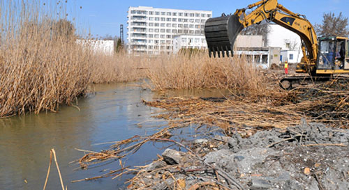
Important specific measures for the protection of the lake are: maintenance of the water regime and in particular the connection with the Black Sea, on which the salinity of the water and other related characteristics of the wetland depend; limitation of industrial pollution; limiting diffuse pollution from adjacent farmland; building control, construction and industrial waste pollution; fisheries control.
In protected area is not allowed: the afforestation of meadows, pastures and meadows, as well as their conversion into arable land and permanent crops; the use of pesticides and mineral fertilizers in pastures and meadows; reed breeding, from 1 March to 15 August – breeding season for bird species occurring in the area; the lighting of reedbeds and coastal vegetation.
The lake is of extremely high ecosystem importance as a key functional element of the Via Pontica migratory road as a “landfill” for biodiversity conservation as a factor for local microclimate and as a prerequisite for the development of environmentally friendly forms of economic activity (eg ecotourism, well regulated use of water and fish resources).
Here are the main threats for Vaya lake as a result of human activity:
- Flushing, tilting and aligning the bottom;
- Reduction of the total area of the lake and open water surface;
- Reduction of the saltity;
- Dangerous pollution with petroleum products;
- Low-flying planes;
- Soil erosion;
- Fertilization of agricultural land and pollution with pesticides;
- Deterioration of water quality;
- Drainage of individual parts;
- Construction;
- Pollution with household waste;
- Excessive catches of fish and the use of dangerous fishing methods;
- Poaching;
- No good connection of the lake with the sea;
- Dangerous to the birds power lines;
- Disturbing of birds;
- Lack of suitable breeding grounds;
- Fishes with non-native fish species;
- Deforestation;
- Forest and field fires;
- Noise pollution;
- Pollution by waste water and others.
1.2 Possibilities
Along with the threats, there are significant benefits that should be used as options for the future development of ecosystem services in the Vai Lake area:
- Close and easy access of the people from Burgas and the surrounding villages to the lake;
- Existence of a large biodiversity, protected areas, forest areas, numerous cultural and historical sites in and around the lake;
- Part of the Via Pontica migratory road.
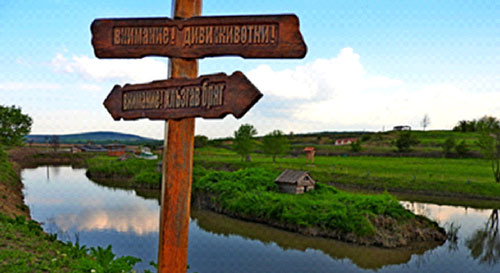 Lake Vaya plays a huge role in the life of the people of Burgas and the region. Among the ecosystem services it provides, these with the greatest weight are the regulators and the supporters. Its buffer functions are the buffer for the rainwater from the rivers flowing into it, the sediment filter and the polluted water filter from the industrial enterprises, especially the oil refinery, the municipal waste landfill, the purification plant, the inert materials quarry, etc.The lake diversifies the lives of many people, offering them a number of cultural ecosystem services. It is within this group that the largest underdeveloped potential of the lake lies.In the future, measures can be taken to further develop activities such as:- Observation and study of birds;- Study visits with students and scientists;- Construction of visitors’ centers, pedestrian and bicycle routes, bird watching towers and other interactive methods for presenting and studying nature and biodiversity;- Development of water sports;
– Combining sea tourism with visits to natural and historical landmarks.
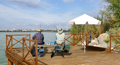
2 Gala lake
2.1 Human impact
Lake Galla is an alluvial freshwater lake with artificial wall located 10 km from the town of Enez and 23 km from Ipsala in the Edirne province of Turkey, near the Maritza delta. It consists of two parts called Big Gala and Little Gala. It has an area of 5.6 km2 and is 2 m above sea level. The depth varies between 0.4-2.2 m. The lake is mainly fed by a drainage channel, starting from the Maritsa River, which regulates the water level and serves for irrigation of the extensive rice fields surrounding the lake.
The production of rice is the main human activity in the region of Ennez. 25% of Turkey’s rice production is produced here. Accordingly, this activity determines the most significant anthropogenic impact on ecosystems and natural resources. It also relates to the main threats to biodiversity and the quality of ecosystem services related to soil, water and air pollution.
Between the cities of Enez and Ipsala, rice has been cultivated for decades on the same farmland as monoculture. This leads to a significant depletion of the soils, which necessitates their intensive fertilization.
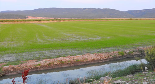
The level of phosphates, sulphates, nitrites and nitrates used in agriculture is expected to be high in wetlands such as Lake Gala, which are surrounded by intensive agricultural areas. However, the entry of sulphate and phosphate ions into the lake’s waters is partly limited by the dense reed bedshows between it and the agricultural lands as well as the drainage channels. But this leads to a decrease in the lake’s water surface, stimulating faster growth and expansion of the reed areas. (Güher H., S. Erdoğan, T. Kırgız, B. Çamur-Elipek, The Dynamics of Zooplankton in National Park of Lake Gala (Edirne-Turkey), www.researchgate.net, August 2011).
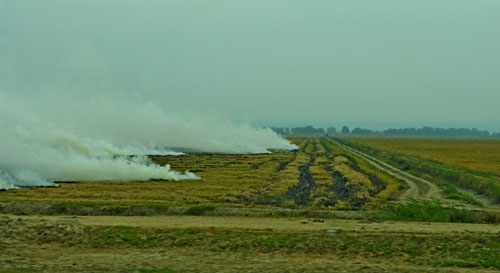
The main threats to the ecosystem services in the area of Lake Gala are:
– Intensive monoculture farming;
– Pollution of soils and waters with pesticides;
– Burning of stubble after harvesting of rice;
– Intensive livestock farming within the pond;
– Poaching of wild species;
– Generation of electricity through wind turbines located on the migratory path of birds
2.2. Possibilities
The area of lake Gala has enormous potential and good prospects for future ecosystem services development. First of all, a balance must be sought between the current intensive use of some of the natural resources and the development of new services.
- Easy access through a new road infrastructure to a large flow of people from the big cities of Istanbul and Edirne, as well as the whole of Turkey;
- Existence of a large biodiversity, protected areas, forest areas, numerous cultural and historical sites in and around the lake;
- Extensive and unspoiled beaches on the Aegean coast;
- Proximity to the mouth of the Maritza River;
- An abundance of historical and archaeological sites in the city of Enez;
- Part of the Via Pontica migratory road.
Inthe future, activities such as:
– Observation and study of birds;
– Study visits with students and scientists;
– Construction of visitors’ centers, pedestrian and bicycle routes, bird watching towers and other interactive methods for presenting and studying nature and biodiversity;
– Development of water sports;
– Combining sea tourism with visits to natural and historical landmarks.
Association Green Strandja
Burgas, 2018
You can download the file from the link above.
Project „”Measures for conservation and restoration of natural heritage in Burgas and Enez” (MoreCare)“, ref: CB005.1.115, „ Elaboration of a joint model and methodology for assessment of the eco system services in the lakes Vaya in Burgas, Bulgaria and Gala in Enez, Turkey“
JOINT MODEL AND METHODOLOGY FOR ASSESSEMENT OF THE ECOSYSTEM SERVICES FOR THE LAKES VAYA (BURGAS) AND GALA (ENEZ)
Assossiation Green Strandja
Burgas, November 2018
Content
1 Context 1
2 Ecosystem services. 2
3 Methodology for assessment of the ecosystem services. 2
3.1 Mapping of ecosystems. 2
3.2 Assessement of the condition of the ecosystems . 4
3.3 Assessement of the ecosystem services. 4
Context
Lake Burgas or Vaya is the largest natural lake in Bulgaria. The lake is a shallow liman on the Black Sea coast, located west of Burgas. In its western part flows Aitoska River, Sunderere and Chukarska River.
Burgas Lake is part of the Burgas Lake Complex, one of the three most important wetland complexes for concentrated waterfowl on the Bulgarian Black Sea coast.
Burgas Lake is a site of extremely important international conservation importance declared for:
- protected area (ЗЗ BG0000273) under both directives – The Habitats Directive and the Birds Directive
- Ornithologically important place (BirdLife International, 1989) the lake is located on the Via Pontica migratory road and is one of the most important stations for bird migration
- Wetland of international importance under the Ramsar Convention (2003)
- CORINE place due to its European importance for the conservation of rare and endangered bird species (1998)
The Vaya protected area of 75 ha covering 12% of the lake.
In the area of the lake there are 245 bird species, 71 of which are included in the Red Book of Bulgaria (1985). Of the species present, 105 are of European conservation importance, 9 of them are endangered globally and 95 species (Standard Natura 2000 form) are endangered in Europe. The lake provides suitable habitats for 89 species of birds included in Appendix 2 of the Biodiversity Act and is of international importance for the wintering of species such as Cormorant, Swan, Swallow, Great White-fronted Goose, Brown-headed Duck, and Scotch Duck. Also in winter were the worldly endangered Dalmatian Pelican and Red-breasted Goose. The lake is one of the most important places in the country of importance to the European Union for the conservation of the Thorn-tailed Duck and the breeding small water bull.
The lake is subjected to strong anthropogenic pressure (waste water, construction and household waste, heavy building, noise, industrial fishing). The free movement of fish through the canal connecting the lake and the sea is obstructed because the canal is almost entirely enclosed. The lake is polluted by petroleum products, phenols and other chemicals as a result of the nearby oil refinery. All these factors can lead to a change in the quality of water, a change in the type and quantity of fish stocks and, respectively, in the food base for many protected waterfowl.
Ecosystem services
In the project work, the CICES classification will be used as a basic classification of ecosystem services (ESS). It is recommended for work on ecosystem services by the European Commission and MAES (Mapping and Assessment of Ecosystems and their Services) as well as the methodology used in the redefined project BG03 – MethEcoSMap “Methodological support for ecosystem services assessment and biophysical assessment “Of subprogram BG03.02” Biodiversity and ecosystem services “financed by FM / EEA.
According to the classification, ESSs are divided into:
- Food (food, genetic resources, medicinal plants, wood, fiber, etc.)
- regulating and supporting (climate, pollination, water circle, soil formation, water quality, biological control, etc.)
- cultural (recreational – recreation, spiritual benefits, aesthetic benefits, educational and scientific activity, etc.)
Methodology for assessment of ecosystem services
The methodology which will be used for ecosystem services (ESS) assessment of Lake Burgas (Lake Vaya) and Lake Gala near Enez will follow a national methodological framework for assessing the state of ecosystems in Bulgaria and their potential to provide services (in the process of validation).
In general the steps for assessing the ESS are 3: (1) Mapping ecosystems, (2) Ecosystems assessment and (3) Estimating the ESS, including defining the potential of ecosystems to provide services.
The following are the detailed steps:
Mapping of ecosystems
Mapping of ecosystems is based on:
- Use of available national freshwater ecosystems databases – Cadastre, LPIS, LSA, Corine;
- Use of pan-European High Resolution Layers;
- (HRL) of the Copernicus program;
- Use of satellite images;
- Drawing the final boundaries of the objects.
For mapping purposes, ecosystems are divided into types according to the so-called MAES typology (2013) of three basic types of level 1: land, freshwater and marine.
Below is the typology of freshwater ecosystems in Bulgaria:
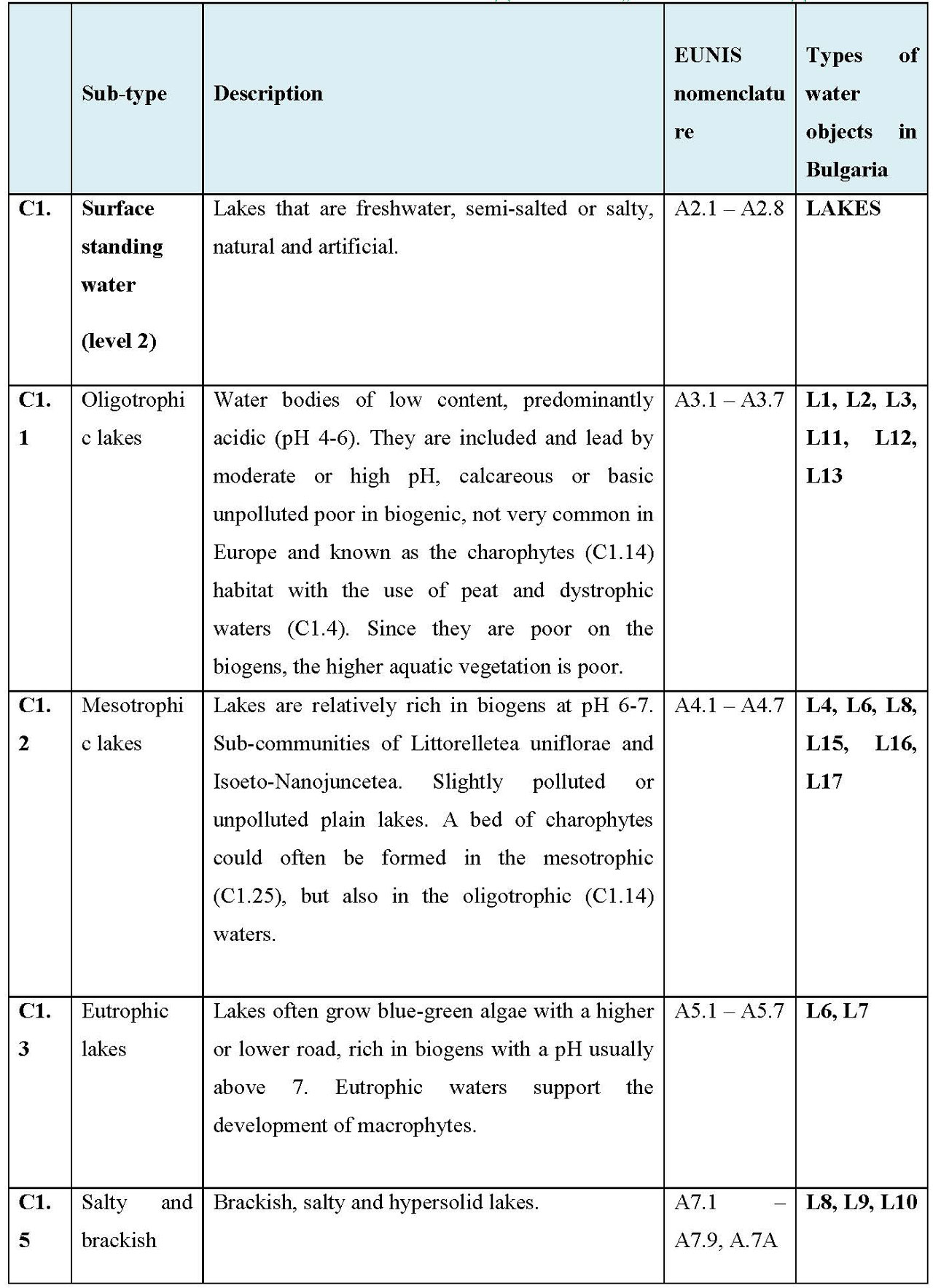
Assesseemnt of the condition of the ecosystems[1]
The assessment of the current state of ecosystems is based on field studies through defined indicators. The indicators for assessment of the status of all ecosystem types in Bulgaria are hierarchically grouped in types and groups according to the recommendations of MAES (2013).
Key indicators that are used to assess the status of ecosystems are:
Conservation status of habitats and species
- Ecological status of water bodies
- Biodiversity status
- Presence of invasive species
- Hydrologic heterogeneity
The data sources used at this stage should be tailored to the specificity of each assessment indicator.
The main data used for the assessment are:
- Evaluation of the habitats under Art. 17 of the Habitats Directive
- Evaluation of the Water Framework Directive (WFD)
- Data on water, soil, air pollution
- Pressure / impact data causing changes in ecosystems (eg climate change, anthropogenic pressure, invasive species, etc.)
A detailed description of the steps to determine the status of freshwater ecosystems is given in the study: “Freshwater and Marine Ecosystems: Status, Services, Perspectives”.
The overall assessment of each group of indicators proposed in the methodology (indicators of the status of ecosystems for freshwater ecosystems) is calculated as the average of the results for the indicators included for the specific sub-type of freshwater ecosystem. The final mark must be given as an integer. (See Table 5 and 6 of the Methodology).
Assessement of the ecosystem services
At this stage, information is collected on what types of ESSs are provided and / or sought, where and on what scale, in order to quantify the potential for ESS use and how this would affect the functioning of ecosystems. Possible sources of information can be:
- MOEW – EEA – Basin Directorates, National Database
- National statistics
- Municipalities
- National Cadastre
- Scientific publications
- Projects
- In-situ data
- Data sources from / within the EU
- Data from remote observations
- Direct polls and interviews with experts
The ESS is assessed on the basis of specifically defined assessment indicators. Freshwater ecosystem services indicators have been developed by MAES (2013).
For the assessment of the ecosystem services of the lakes Vaya (Burgas) and Gala (Enez), we will use the following common indicators, which are selected as a result of the collected information and surveys of the two lakes in order to be mutually comparable:
Food ESS
Products from agriculture
Products from livestock
Products from wild animals, plants, mushrooms, weeds
Products from aquacultures
Providing drinking and non-drinking water
Energy sources
Regulating ESS
Purification of air and water from pollutants
Soil stabilization and regulation of erosion processes
Regulation of the water cycle – flood protection and drought protection
Providing habitat types and conditions for population continuation
Microclimate regulation
Cultural ESS
Experience the connection with the environment
“Carrying science researches and educational programmes”
Historical and cultural heritages
Leisure and entertainment
Natural heritage, existence of protected areas
To determine the ecosystem capacity to provide ecosystem services, we will fill out a matrix of selected ecosystem services indicators, in which the assessment of each indicator is graded in a five-step scale from 1 to 5 as follows:
1 – Strongly degraded
2 – Degraded
3 – Moderately degraded / Somewhat developed potential
4 – Not entirely developed potential
5 – Optimal / well-developed potential
To be more objective, we evaluate ecosystem services separately for the current state of ecosystems and their future potential.
As a result of the surveys carried out for both lakes, the assessment of ecosystem services itself will be carried out according to the defined indicators for their current status and development potential separately
Association Green Strandja
Burgas, 2018
You can download the file from the link above.
Project „”Measures for conservation and restoration of natural heritage in Burgas and Enez” (MoreCare)“, ref: CB005.1.115, „ Elaboration of a joint model and methodology for assessment of the eco system services in the lakes Vaya in Burgas, Bulgaria and Gala in Enez, Turkey“
COMPARATIVE ANALYSIS
AND ASSESSMENT OF THE ECOSYSTEM SERVICES OF
THE LAKES VAYA (BURGAS) AND GALA (ENEZ)
Association „Green Strandja“
Burgas, November 2018
According to the definition of the global initiative “Economics of Ecosystems and Biodiversity” (TEEB), ecosystem services are the contribution of ecosystems to human well-being. Ecosystem services can be divided in general into:
* Supportive services – services that create the conditions necessary to provide all other ecosystem services, such as photosynthesis or soil formation.
* Food Services (Material services) – all products originating from ecosystems, for example foods, fibers, fuels, herbs and medicinal plants, genetic material, drinking water.
*. Regulating services – the ability of ecosystems to regulate important natural natural processes such as climate regulation, quality and quantity of waters and so on.
* Cultural services – intangible benefits of ecosystems, such as the aesthetic and recreational value of the landscape.
Today, through our activities, we often exploit natural resources, influencing the ability of ecosystems to provide us with their useful services. In May 2011, the European Commission adopted a Message “Our life insurance, our natural capital: an EU biodiversity strategy for 2020″(COM [2011] 244), in which the 2020 target includes halting the degradation of ecosystem services and their restoration. Objective 2 is to ensure that: “By 2020, ecosystems and their services will be maintained and improved by creating green infrastructure and recovering at least 15% of the ecosystems affected. This includes mapping and assessment of ecosystems and their services. The Communication was followed by a European Parliament resolution adopted in April 2012.
In May 2013, the European Commission adopted the Green Infrastructure (GI) Message – Increasing the Natural Capital of Europe. It defines green infrastructure as a “strategically planned network of natural and semi-natural areas and other environmental elements that is constructed and managed to provide the most diverse ecosystem services.” The concept focuses on maximizing services based on the integration of natural solutions into spatial planning and spatial development.
The ecosystem services of the two lakes – Vaya (Burgas, Bulgaria) and Gala (Enez, Turkey) are determined by the natural-geographic features, the historical development and the current socio-economic conditions of the two regions. They have their own characteristic features but also have many common components.
Both lakes are located in coastal areas, in close proximity to settlements, surrounded by highly urbanized areas, located at approximately the same altitude, almost equal to the sea level, conserving exclusively biodiversity and representing nature conservation sites from local, regional and international importance. The lakes and their adjacent areas are sources of natural products, food, energy, water for drinking and non-drinking needs, herbs and medicinal plants, they also store valuable genetic material. They perform a number of supportive and regulatory functions for ecosystems and people’s lives, including climate, water quality and quantity, air cleanliness, and more. They have a huge impact on the quality of life of people, bringing them considerable and varied intangible benefits.
When assessing ecosystem services, food, regulatory and cultural services are identified using measurable and comparable indicators that are directly related to people’s lives.
For the assessment of the ecosystem services of the lakes Vaya (Burgas) and Gala (Enez), we will use the following common indicators, which are selected as a result of the collected information and surveys of the two lakes in order to be mutually comparable:
- Food ESS
- Products from agriculture
- Products from livestock
- Products from wild animals, plants, mushrooms, weeds
- Products from aquacultures
- Providing drinking and non-drinking water
- Energy sources
- Regulating ESS
- Purification of air and water from pollutants
- Soil stabilization and regulation of erosion processes
- Regulation of the water cycle – flood protection and drought protection
- Providing habitat types and conditions for population continuation
- Microclimate regulation
- Cultural ESS
- Experience the connection with the environment
- “Carrying science researches and educational programmes”
- Historical and cultural heritages
- Leisure and entertainment
- Natural heritage, existence of protected areas
To determine the ecosystem capacity to provide ecosystem services, we will fill out a matrix of selected ecosystem services indicators, in which the assessment of each indicator is graded in a five-step scale from 1 to 5 as follows:
1 – Strongly degraded
2 – Degraded
3 – Moderately degraded / Somewhat developed potential
4 – Not entirely developed potential
5 – Optimal / well-developed potential
To be more objective, we evaluate ecosystem services separately for the current state of ecosystems and their future potential.
ASSESSMENT OF THE ECO SYSTEM SERVICES OF THE LAKES VAYA (BURGAS, BULGARIA) AND GALA (ENEZ, TURKEY)
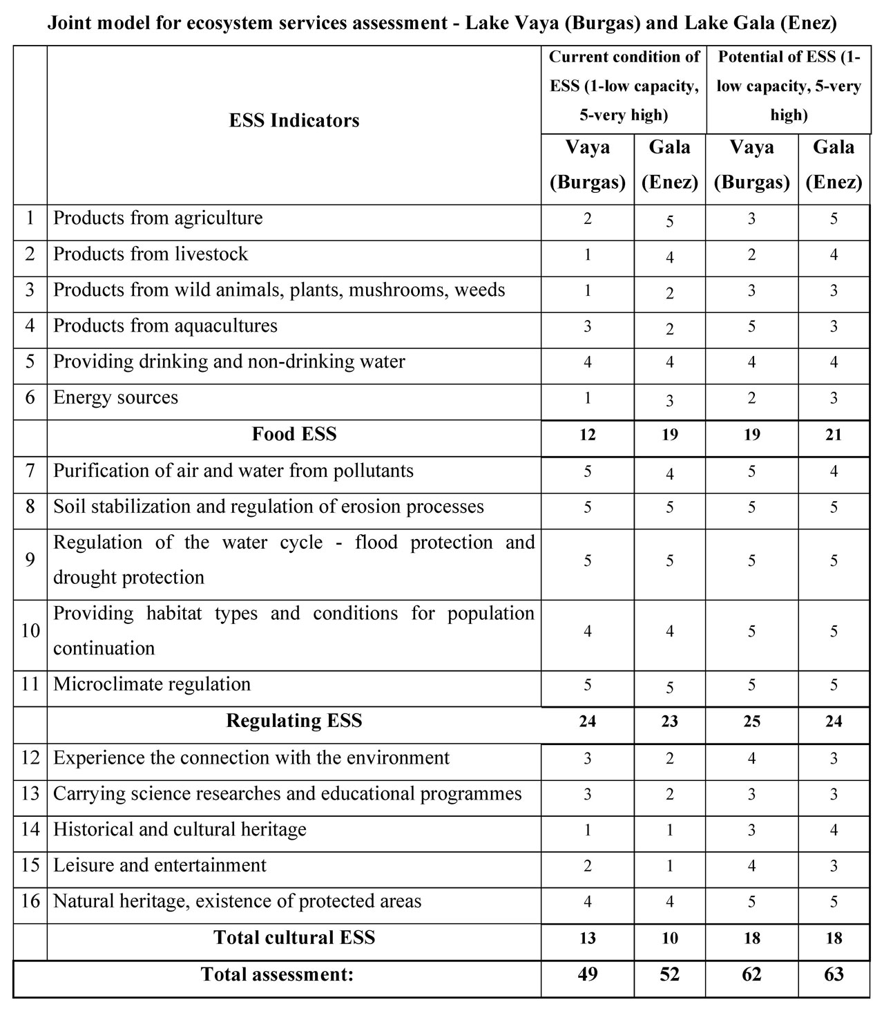
Analysis of the assessment of ESS
Food ESS
Indicator 1 /Products from agriculture/ – The higher and maximum estimate (5) of this indicator in Lake Gala is due to the presence of pastures and the adjacent rice fields.
Indicator 2 /Products from livestock/ – The higher estimate /4/ of this indicator is due to the fact that in the pastures of the Gala Lake are fed and rest many animals (grazing and resting cows and sheeps).
Indicator 3 /Products from wild animals, plants, mushrooms, weeds/ – According to the director of Lake Gala National Park, 29 species of herbs are collected in the area of the lake, which explains the higher score /2/ of this indicator.
Indicator 4 /Products from aquacultures/ – The higher estimate /3/ of this indicator for Lake Vaya is due to the fact that in recent years it has regained its reputation as a source of fish and in the present moment fishing is estimated to be around 200 250 tons / Current state of the protected areas in Southeastern region of Bulgaria, 2014 / and is expected to grow in the future. The Lake Gala Park has been place for fishing until 2013, after which fishing there is banned. Currently fishing is in the Maritsa River, in the two dams built around the Maritsa River, as well as in the rice fields. For both lakes, plans are being made to phase out fishing, so higher estimates are expected in the future.
Indicator 5 / Providing drinking and non-drinking water/ – The waters of lake Vaya regulate and maintain high levels of groundwater in the area and this helps to use them as irrigation water in the adjacent areas of the lake. Lake Gala plays the role of a water reservoir, which, if necessary, takes over the excess water from the fields of rice, and in the summer it is used for irrigation. Therefore, an equal score /4/ on this indicator is given on both lakes.
Indicator 6 / Energy sources/ – The higher estimate /3/ of this indicator in Lake Gala is due to the presence of park wind power generators and, therefore, the lack of such in Lake Vaya.
Regulating ESS
Indicator 7 /Purification of air and water from pollutants/ – Both lakes are sediment and filter for polluted water from adjacent industrial plants, households and agricultural activities in the areas. In this respect Lake Vaya plays a more important role in people’s lives because it is situated in the borders of the city of Burgas, with a population of 202 694 people (according to NSI data as from 31.12.2017). The lake is a filter for domestic waste water, water contaminated by surrounding businesses, and especially the oil refinery, inert aggregate sludge and municipal waste landfill before it flows into the Black Sea. On the other hand, as
the largest non-urbanized surface on the territory of the city and a living environment for different types of aquatic and moisture-loving chlorophyll plants, the lake purifies and dilutes the concentration of pollutants in the air of Burgas. So we can define it as the city’s lung.
Indicator 8 / Soil stabilization and regulation of erosion processes/ – Maximum estimates for both lakes taking into account their importance in supporting soil fertility, related to improving the microclimate and maintaining the groundwater level, and their role as an obstacle to shore erosion. Passing into the lakes, the torrents of surrounding tributaries are calming down, thus reducing the transfer of sediment and soil erosion.
Indicator 9 /Regulation of the water cycle – flood protection and drought protection/ – Maximum estimates for both lakes taking into account their role as a buffer for torrential rainwater flowing from rivers and real barriers that reduce the risk of coastal flooding associated with ongoing climate change.
Indicator 10 /Providing habitat types and conditions for population continuation/ – In both lakesbiodiversity is extremely high, and therefore their importance as a “landfill” for biodiversity conservation and as a guardian of genetic resources is immense. The rating for Lake Vaya is slightly lower due to its proximity to a large city, busy roads, higher urbanization and pollution.
Indicator 11 / Microclimate regulation/ – Maximum estimates for both lakes as important factors for the local microclimate, especially for expected climate change in the near future.
Cultural ESS
Indicator 12 /Experience the connection with the environment/ – Outstanding natural resources and rich biodiversity are the basis for developing ecological tourism and recreation. Lakes diversify people’s lives through the opportunities they offer for spiritual and aesthetic enjoyment from nature as well as for educational and scientific work. The estimates indicate insufficient use today and real potential for this in the future.
Indicator 13 / Carrying science researches and educational programmes / – Both lakes are very useful and favorite places for ornithologists. A regular visit by students, students and scientists to study biodiversity (birds, animals, plants) is organized. The evaluation of this indicator for Lake Gala is lower due to a lack of infrastructure and logistics. Opportunities and intentions for the future are greater.
Indicator 14 / Historical and cultural heritage / – Estimates in both lakes are currently very low, but opportunities for combining the extremely rich natural and archaeological monuments and landmarks in the areas as well as combining them with sea tourism are discussed.
Indicator 15 / Leisure and entertainment / – Opportunities for recreation and entertainment are much larger than the ones used so far. The rating for Lake Vaya is slightly higher because the territory is already the subject of specialized (mainly ornithological) tourism and sport fishing. There are currently discussions over the organization and construction of the necessary infrastructure in both lakes for the development of water sports, cycling, photo-tourism, hiking, fishing, etc.
Indicator 16 / Natural heritage/ – The unique biodiversity and natural resources in the areas of both lakes define them as sites with a special status in terms of conservation of the natural heritage. They are nature conservation sites of local, regional and international importance.
Association Green Strandja
Burgas, November 2018
You can download the file from the link above.